Map Types
Continents and Oceans
Lines of Latitude & Longitude
Culture and Globalization
Themes of Geography
100
A map that uses color to show elevation and landforms
Physical Map
100
What are the coordinates for A?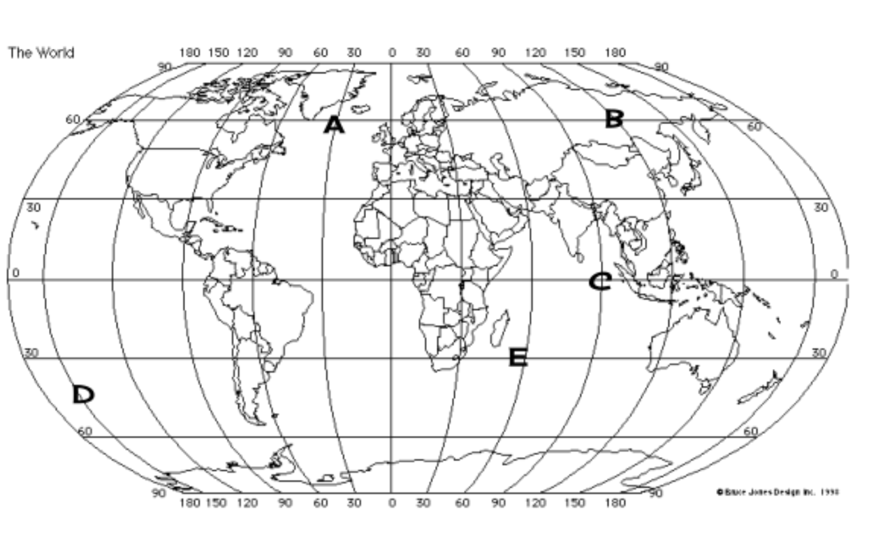
(60*N, 30*W)
100
Lines that run from the North Pole to the South Pole
Lines of Longitude
100
How people in a region live, think, and behave.
Culture
100
A construction company is cutting down a forest to use the trees and the wood.
HEI
200
A map that shows political boundaries, such as state and national borders
Political Map
200
What are the coordinates for B?
(60*N, 150*E)
200
The imaginary lines that run parallel to the Equator are called
Lines of Latitude
200
Cultural, economic, and political connections between different parts of the world
Globalization
200
The people of Venice, Italy often use river taxis to get from one point to another.
Movement
300
A map designed to show a specific topic, such as population density or climate
Thematic Map
300
What are the coordinates for C?
(0*, 90*E)
300
The imaginary line that circles the earth at 0° latitude
Equator
300
An ancient example of Globalization.
The Silk Road
300
Southerners in the U.S.A. are often grouped together as one because of a common accent and other common interests.
Region
400
Type of Map that is rectangular and distorts the size of countries near the poles.
Mercator Projection
400
What are the coordinates for E?
(30*S, 60*E)
400
The zero-degree line of longitude
Prime Meridian
400
A drawback of Globalization
Loss of jobs, spread of disease, and loss of unique cultures.
400
The U.S. is located south of Canada.
Location
500
A more rounded on the edges map that has curved lines of longitude that we will often use in this class.
Robinson Projection
500
What are the coordinates for D?
(45*S, 150*W)
500
The maximum number degrees latitude and longitude.
90* Latitude and 180* Longitude
500
Benefit of Globalization
Increased wealth from trade, spread of technology and ideas, or the sharing of culture.
500
The people of Ireland often wear traditional clothing, such as a kilt, during holidays or celebrations.
Place