Regions, Location
Regions, Weather
Landforms
Parts of a Map
Vocabulary
100
What is the green region called?
¿Cómo se llama la región verde?

Southwest
Suroeste
100
What type of weather is in the Southwest region?
¿Qué tipo de clima hay en la región suroeste?
Hot, dry, long summers, short winters
Veranos calurosos, secos y largos, inviernos cortos.
100
What is a mountain?
¿Qué es una montaña?
An elevated piece of land, normally higher than 1,000 feet, that is difficult to cross by foot
Una elevación del terreno, normalmente de más de 300 metros, que es difícil de atravesar a pie.
100
What is the legend or key of a map?
¿Qué es la leyenda o clave de un mapa?
The area of a map that tells you what the colors and symbols represent
El área de un mapa que indica lo que representan los colores y los símbolos.
100
What does urban mean?
¿Qué significa urbano?
Having to do with or relating to a city
Que tiene que ver con una ciudad o está relacionado con ella.
200
What is the blue region called?
¿Cómo se llama la región azul?

Southeast
Sureste
200
What type of weather is in the Southeast region?
¿Qué tipo de clima hay en la región sudeste?
Hot, wet, rainy, with long summers and short winters
Cálido, húmedo, lluvioso, con veranos largos e inviernos cortos.
200
What is a plain / prairie?
¿Qué es una llanura o pradera?
A large flat area of land, normally with very few trees, and a good area to grow food
Una gran extensión de terreno llano, normalmente con muy pocos árboles, y una buena zona para cultivar alimentos.
200
What does a map title do?
¿Para qué sirve el título de un mapa?
It tells you the purpose of the map
Te indica el propósito del mapa.
200
What does rural mean?
¿Qué significa rural?
Having to do with or relating to the countryside
Que tiene que ver con el campo o se relaciona con él.
300
What is the pink region called?
¿Cómo se llama la región rosa?

Northeast
Noreste
300
What type of weather is in the Northeast region?
¿Qué tipo de clima hay en la región noreste?
Very cold winters, short summers
Inviernos muy fríos, veranos cortos.
300
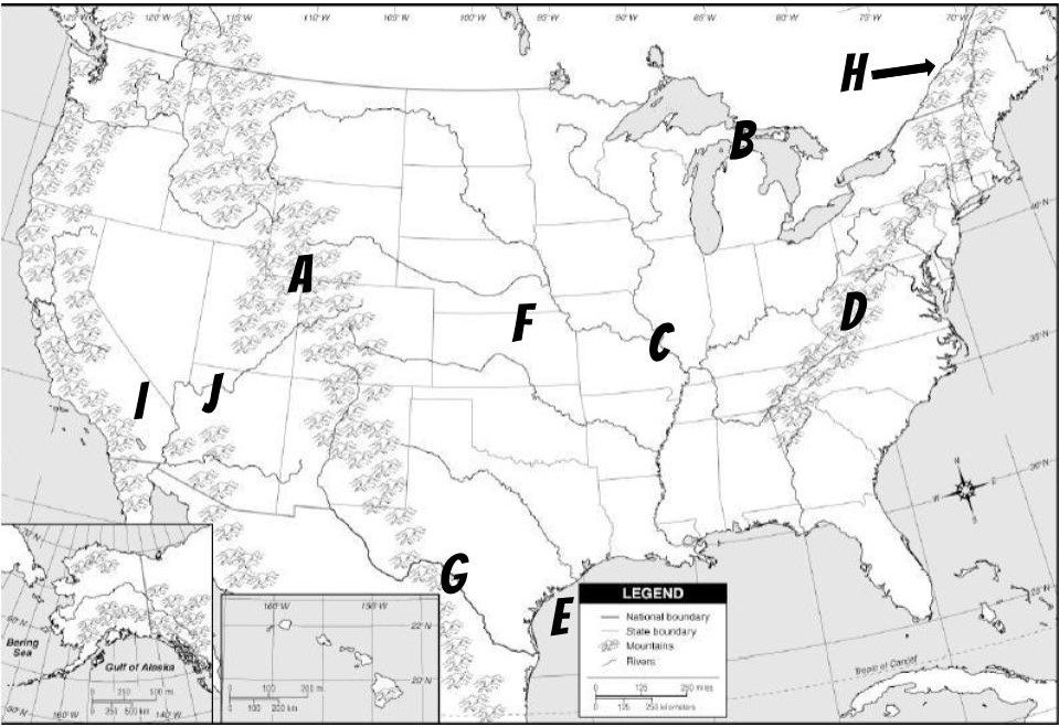 What is located at letter C?
¿Qué se encuentra en la letra C?
The Mississippi River
El río Mississippi
300
What do symbols and colors do on a map?
¿Qué función tienen los símbolos y los colores en un mapa?
They represent different items on a map, such as water or cities
Representan diferentes elementos en un mapa, como agua o ciudades.
300
What does suburban mean?
¿Qué significa «suburbano»?
The area just outside a city, normally with less business areas and mostly neighborhoods
La zona situada a las afueras de una ciudad, normalmente con menos áreas comerciales y compuesta principalmente por barrios.
400
What is the orange region called?
¿Cómo se llama la región naranja?

West
Oeste
400
What type of weather is in the Midwest region?
¿Qué tipo de clima hay en la región del Medio Oeste?
Very cold winters, medium summers, good for growing crops in more southern areas
Inviernos muy fríos, veranos templados, buenos para el cultivo en las zonas más meridionales.
400
 What is located at letter A?
¿Qué se encuentra en la letra A?
The Rocky Mountains
Las Montañas Rocosas
400
What is a scale?
¿Qué es una escala?
It is a way to measure distance on a map
Es una forma de medir la distancia en un mapa.
400
What does physical feature mean?
¿Qué significa «característica física»?
It is the actual shape of the land outside
Es la forma real del terreno en el exterior.
500
What is the yellow region called?
¿Cómo se llama la región amarillo?
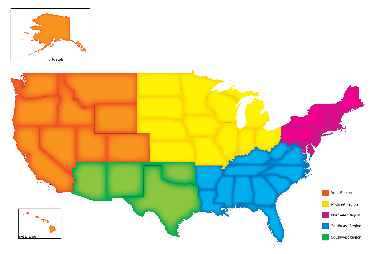
Midwest
medio oeste
500
What type of weather is in the West region?
¿Qué tipo de clima hay en la región occidental?
Many different kids of weather because of the many different states; cold in the north and warm in the south
Muchos tipos diferentes de clima debido a los muchos estados diferentes; frío en el norte y cálido en el sur.
500
 What is located at letter D?
¿Qué se encuentra en la letra D?
The Appalachian Mountains
Los Montes Apalaches
500
What do latitude and longitude lines do on a map?
¿Qué función tienen las líneas de latitud y longitud en un mapa?
They create a grid system to make it easier to find things on a map
Crean un sistema de cuadrículas para facilitar la búsqueda de elementos en un mapa.
500
What does geography mean?
¿Qué significa geografía?
It means the study of the world (geo means world, and graphy means study)
Significa el estudio del mundo (geo significa mundo y grafía significa estudio).