Maps
Landforms
Asia
Random
100
Shows territory divisions made by men.
Political Maps
100
A flat area of land between mountains.
What is a valley?
100
Small defacto country.
What is Taiwan?
100
Imaginary lines that divide the globe North to South.
What is Longitude?
200
Images representing the continents, oceans, islands and other features of the world. Images can seem a bit distorted.
Maps
200
Extension of land that reaches out into the ocean.
What is a peninsula?
200
The largest island in the archipelago East of China.
What is Japan?
200
A scientist that studies Earth's features.
What is a Geographer?
300
Group of symbols that explain what images on a map mean.
What is a Map Key?
300
A narrow strip of land that connects two large extensions of land.
What is an isthmus?
300
Small archipelago southeast of China 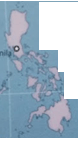
What is the Philipines?
300
The important line of latitude that divides the globe into Northern Hemisphere and Southern Hemisphere.
What is the Equator?
400
It shows the four cardinal points on a map.
What is a Compass Rose?
400
Flat rise of land with steep sides.
What is a plateau?
400
A small island south of India.
What is Sri Lanka?
400
We use the acronym MR HELP remember their names.
What are the 5 themes of Geography?
500
It shows landforms and bodies of water on this kind of map.
What is Physical Map?
500
A large inlet of the ocean into land with a narrow opening.
What is a Gulf?
500
Small city-island south of the Malay Peninsula.
What is Singapore?
500
Imaginary lines that divide the globe horizontally.
What is Latitude?