Weather Instruments
Isolines
High vs. Low Pressure
ESRT Charts
Miscellaneous
100
Which weather instrument is most useful in measuring relative humidity?
psychrometer
100
True or False:
Isolines can NEVER cross.
TRUE
100
What is the usual surface wind pattern within a Northern Hemisphere high-pressure system?
- clockwise and outward
- clockwise and inward
- counterclockwise and outward
- counterclockwise and inward
-pressure system?
1. clockwise and outward
100
In which atmospheric temperature zone does most precipitation occur?
troposphere
100
The diagram below shows an instrument used in weather forecasting.
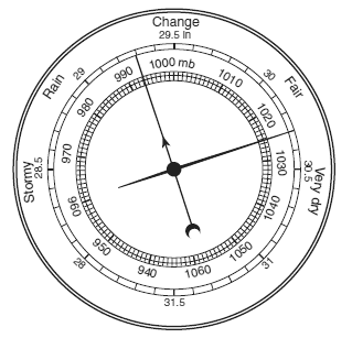
What is this instrument called, and what does it measure?
barometer
measures air pressure
200
What instrument measures wind speed?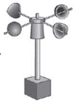
anemometer
200
Isotherms connect points of equal...
temperature
200
The presence of which atmospheric condition will most likely result in cloudy skies and rainy weather in Elmira, New York?
- high-pressure center
- low-pressure center
- increasing wind speed
- cooling temperatures
2-low pressure center
200
A barometric pressure of 1021.0 millibars is equal to how many inches of mercury?
- 29.88
- 30.15
- 30.25
- 30.50
2) 30.15
200
Which condition will most likely result in the formation of a cloud?
- wind speed decreasing
- air pressure increasing
- cool, moist air sinking
- warm, moist air rising
4. warm, moist air rising
300
What weather instrument was most likely used to measure these air pressures?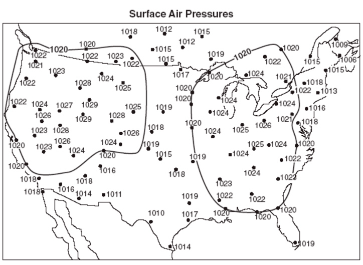
barometer
300
Isobars connect points of equal...
air pressure
300
Identify one possible air pressure at the center of the low pressure system.
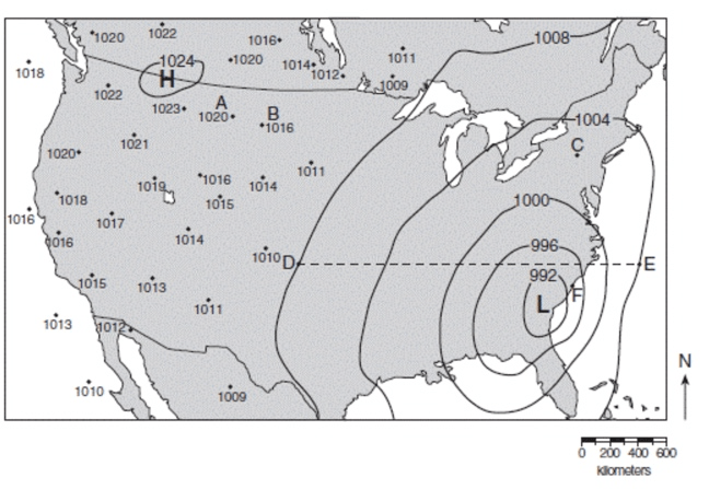
991
990
989
300
A student using a sling psychrometer measured a wet-bulb temperature of 10°C and a dry-bulb temperature of 16°C. What was the dewpoint?
- -10°C
- 45°C
- 6°C
- 4°C
4) 4°C
300
Air pressure is usually HIGHEST when the air is
1) warm and humid
2) warm and dry
3) cool and humid
4) cool and dry
4) cool and dry
400
Which list correctly matches each instrument with the weather variable it measures?
wind vane—wind speed
thermometer—temperature
precipitation gauge—relative humiditywind vane—wind direction
thermometer—dewpoint
psychrometer—air pressurebarometer—relative humidity
anemometer—cloud cover
precipitation gauge—probability of precipitation- barometer—air pressure
anemometer—wind speed
psychrometer—relative humidity
barometer—air pressure
anemometer—wind speed
psychrometer—relative humidity
400
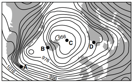
Which location was probably experiencing the highest wind speed?
1) A
2) B
3) C
4) D
1) A
400
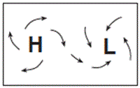
Which map best represents the surface wind pattern around Northern Hemisphere high-pressure and low-pressure centers?
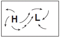
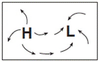
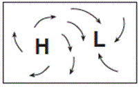
3) 
400
Most ozone is found in a region of Earth’s atmosphere between 10 and 20 miles above Earth’s surface. This temperature zone of the atmosphere is known as the
stratosphere
400
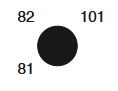
Which weather station model indicates the greatest probability of precipitation?
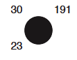
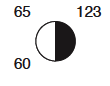
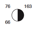
2) 
500
Students wish to study the effect of elevation above sea level on air temperature and air pressure. They plan to hike in the Adirondack Mountains from Heart Lake, elevation 2,179 feet, to the peak of Mt. Marcy, elevation 5,344 feet.
Which instruments should they use to collect their data?
- anemometer and psychrometer
- anemometer and barometer
- thermometer and psychrometer
- thermometer and barometer
4) thermometer and barometer
500
The map below shows a weather variable recorded at noon on a certain day. Isolines show values from 992 to 1024.
Which atmospheric variable is most likely represented by the isolines on the map AND what units were used to record these measurements?
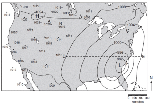
atmospheric pressure
millibars
500
Base your answer to the question on the weather map below, which shows a low-pressure system centered near Poughkeepsie, New York. Isobars shown are measured in millibars.
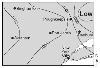
Surface winds are most likely blowing from
- Danbury toward New York City
- Poughkeepsie toward Scranton
- Binghamton toward Danbury
- Port Jervis toward Binghamton
3. Binghamton toward Danbury
"Winds blow from HIGH to LOW pressure"
500
What graph shows the general relationship between altitude and temperature in the troposphere?
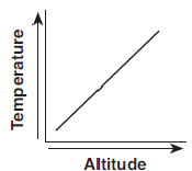
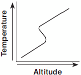
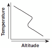
2) 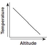
"As altitude increases in the troposphere, temperature decreases."
500
Which cross section best represents how surface winds form by midafternoon near a shoreline on a hot summer day?
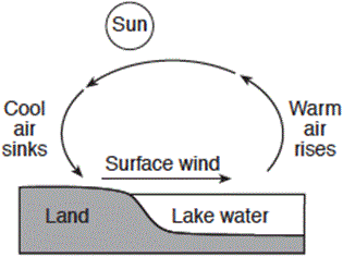
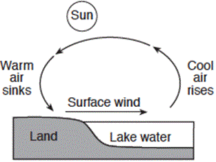
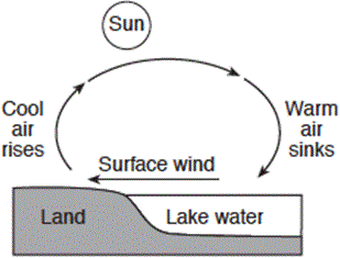
3.
4.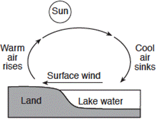
4.