Describe one negative ecological impact that tsunamis have on coastal environments.
Destruction of/loss of habitat such as mangrove forests, coral reefs, etc.
Flooding resulting from tsunami waves can create saltwater intrusion into coastal ecosystems.
Drowning of terrestrial species.
How have organisms influenced soil formation?
Plants remove nutrients from soil and excrete organic acids that speed up chemical weathering. Animals that tunnel or burrow mix the soil, uniformly distributing organic and mineral matter. Soil organisms act as recyclers of organic matter.
What drives the circulation of global winds/Hadley cells?
Solar radiation – the light warms Earth’s surface, creating rising air currents at the equator.
What is the primary cause of Earth’s seasons?
The constant tilt of Earth’s rotational axis with respect to its orbit around the Sun.
Because Earth’s axis of rotations is tilted 23.5 degrees, Earth’s orbit around the Sun causes most regions of the world to experience seasonal changes in temperature and precipitation. The latitude that receives the most direct rays of the Sun and the most hours of daylight changes throughout the year as Earth orbits the Sun.
How do oceans play a role in regulating climate?
Oceans oceans or large bodies of water to provide a stabilize humidity to the air. Humidity in the air tends to stabilize temperature and prevent large fluctuations. Temperatures in regions with dry air will increase and decrease rapidly.
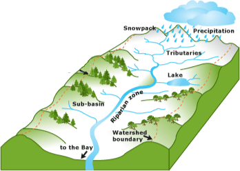
The lake in the diagram is one of the primary points of recharge for the areas aquifer. Assuming an incredibly slow rate of recharge is occurring in the aquifer, identify the particle type that would most likely make up the majority of the soil.

What is clay?
Describe what happens when two tectonic plates collide along a subduction zone. How is a tsunami generated along a subduction zone?
One plate is pushed under another. Tsunamis are generated from underwater earthquakes. Rapid water displacement leads to tsunami formation.
Which of the lettered choices in the soil profile above represents the region with the greatest concentration of organic material? Which letter represents the bedrock?
A, E
What is the Coriolis effect?
The winds at all latitudes to the north of 0° deflect to the right of their intended path in the Northern Hemisphere and to the left in the Southern Hemisphere
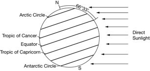
Describe the season and length of day at the Tropic of Cancer at the time of the year shown in the diagram.

The Northern Hemisphere is tilted away from the Sun, so it is winter at the Tropic of Cancer and daylight is less than 12 hours per day. This also makes it colder (winter) due to less intense solar radiation.
Describe two characteristics of El Nino.
Every 2-7 years in the Pacific Ocean
Prevailing tropical trade winds (E → W) weaken or reverse direction
Western Pacific warmer waters move toward South America
Suppress the normal upwellings of cold, nutrient-rich water
Etc.
Describe the characteristics of a watershed. (Give at least 2)
- Land cover: The type of land in a watershed, such as forests, agricultural lands, or cities, can impact infiltration and rainfall runoff.
- Geology: The bedrock geology of a watershed can affect infiltration and runoff rates.
- Topography: The hills, mountains, and sloping topography of a watershed can be thought of as the walls of a funnel.
- Soil: The type of soil, its porosity, permeability, and compaction can impact infiltration capacity.
- Climate: The climate of a watershed can make it distinctive.
- Size, shape, and stream order: These characteristics can affect runoff.
- Cultural features: These include agricultural practices, residential development, and in-stream structures.
- Hydrologic modifications: These can include dams and other modifications
Describe what happens to the tectonic plates along a transform boundary at the moment when an earthquake occurs. What about during the time between earthquakes?
Moment an earthquake occurs: a large amount of energy is released and the plates suddenly/rapidly slide past each other in opposite directions.
Between earthquakes: bind/lock-up causing pressure to build up over time.
Soil quality is a critical factor in agriculture. Identify TWO physical and/or chemical properties of soils and describe their role in determining soil quality.
Physical: depth, color, bulk density, porosity, structure, texture. (role included)
Chemical: pH, organic matter content, CEC, nutrient availability of NPK and others. (role included)
In which layer is the ozone layer found within?
Weather occurs in the ______
The auroras occur in the _______
The majority of molecules in the atmosphere are in the _______
Global warming occurs in the ______
Stratosphere
Troposphere
Thermosphere
Troposphere
Troposphere
Which of the following correctly describes the season and length of day at the Tropic of Cancer at the time of year shown in the diagram?

A. The Northern Hemisphere is tilted away from the Sun so it is winter at the Tropic of Cancer and daylight is less than twelve hours per day.
B. The Northern Hemisphere is tilted away from the Sun, so it is winter at the Tropic of Cancer and daylight is approximately twelve hours per day.
C. The Southern Hemisphere is tilted toward the Sun, so it is summer at the Tropic of Cancer and daylight is greater than twelve hours per day.
D. The Southern Hemisphere is tilted away from the Sun so it is summer at the Tropic of Cancer and daylight is approximately twelve hours per day.
A. The Northern Hemisphere is tilted away from the Sun so it is winter at the Tropic of Cancer and daylight is less than twelve hours per day.
The Northern Hemisphere is tilted away from Sun, which causes shorter days and less intense solar radiation, which makes it colder (winter).
Describe a rain shadow.
Rain Shadows: A region with dry conditions found on the leeward side of a mountain range as a result of humid winds from the ocean causing precipitation on the windward side.
An aquifer is being depleted of its water. How might an ocean nearby negatively effect the water in the aquifer?
Saltwater intrusion: the movement of saltwater into freshwater aquifers, which can contaminate drinking water and harm the environment.
Identify and describe the plate tectonics that lead to new crust forming.
A divergent boundary occurs when two tectonic plates move away from each other. Along these boundaries, earthquakes are common and magma (molten rock) rises from the Earth's mantle to the surface, solidifying to create new oceanic crust.
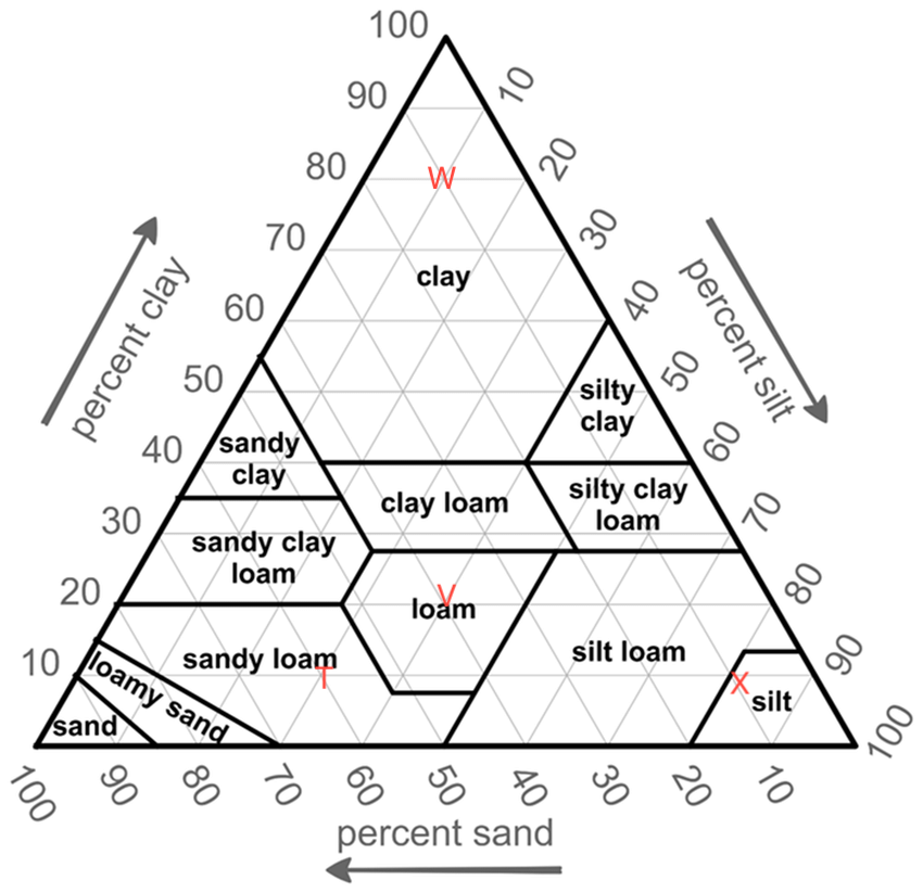
 What are the proportions of sand, silt, and clay for the soil at three of the points shown in the diagram below?
W: 10% sand, 10% silt, 80% clay
V: 40% sand, 40% silt, 20% clay
T: 60% sand, 30% silt, 10% clay
X: 10% sand, 80% silt, 10% clay
Where is Earth’s speed of rotation the fastest? Why? What does this mean for deflection of air currents?
At the equator because the Earth’s circumference is greater near the equator than near the poles. The path of the air current moving toward the equator is deflected to the west.
Which of the following areas receives the most intense solar radiation at the time of year shown in the diagram, and why?
The Tropic of Capricorn, because this latitude is nearly horizontal to incoming solar radiation.
Every few years in the Southern Hemisphere, the trade winds over the Pacific Ocean weaken or reverse direction.
Describe the typical change to the weather pattern that happens to Australia and Southeast Asia during those years.
below average rainfall, particularly in the eastern regions, leading to drier conditions, warmer temperatures, increased bushfire risk, and lower snow depths in the alpine areas
Describe the difference between the global wind patterns in January vs July at location 1. How do winds get their names?
January: Winds come from the north
July: Winds come from the south
They get their names from the direction they originate.
Identify and describe what is occurring at letters B, C, and E.
B: divergent plate boundary, C: convergent (nonvolcanic mountain chain due to uplift), E: convergent (island arcs)
Can you identify and describe 3 of the soil horizons?
O (humus or organic): Mostly organic matter such as decomposing leaves. The O horizon is thin in some soils, thick in others, and not present at all in others.
A (topsoil): Mostly minerals from parent material with organic matter incorporated. A good material for plants and other organisms to live.
E (eluviated): Leached of clay, minerals, and organic matter, leaving a concentration of sand and silt particles of quartz or other resistant materials – missing in some soils but often found in older soils and forest soils.
B (subsoil): Rich in minerals that leached (moved down) from the A or E horizons and accumulated here.
C (parent material): The deposit at Earth’s surface from which the soil developed.
R (bedrock): A mass of rock such as granite, basalt, quartzite, limestone or sandstone that forms the parent material for some soils – if the bedrock is close enough to the surface to weather. This is not soil and is located under the C horizon.
What type of biome is generally found at the equator? What about at 30° N and S? How does the Hadley cell contribute to each biome?
Tropical rainforests and generally found at the equator and deserts at 30° N and S. At approximately 30° N and S, dry air current descend, whereas at the equator, warm air rises.
Explain why is it common to see lush vegetation growing on the windward side of a mountain range and very dry conditions on the leeward side?
When air meets the windward side of a mountain range (the side facing the wind) it rises and begins to experience adiabatic cooling, condensing to form clouds and precipitation. The condensation causes latent heat release, which helps to accelerate the upward movement of the air. Thus, large amounts of precipitation fall on the windward side and the cold, dry air then travels to the leeward side. The air descends and experiences higher pressures as well as adiabatic heating. Here warm, dry air produce arid conditions.
What are some results of a La Niña event? Must give location with description.
Brings especially cool weather to the west coast of the Americas. This can lead to less precipitation in the Americas, and can also increase Tornado severity in the US, and hurricane activity in the Atlantic.
SE Asia sees a return to the rainy conditions they’re used to which can be beneficial to agriculture, but this can also bring extreme flooding, and in increase in monsoon severity.
Colder winters in Canada and NE U.S., wetter winters in Pacific NW, increased phytoplankton concentrations and, as a result, numbers of species higher up the food web because of increased nutrient levels.
Explain how ocean currents affect climate and weather on land?
Ocean currents act much like a conveyor belt, transporting warm water and precipitation from the equator toward the poles and cold water from the poles back to the tropics. Thus, ocean currents regulate global climate, helping to counteract the uneven distribution of solar radiation reaching Earth’s surface. Without currents in the ocean, regional temperatures would be more extreme — super hot at the equator and frigid toward the poles — and much less of Earth’s land would be habitable.