Unit 1
Unit 1
Unit 2
Maps
Unit 3
Unit 4
Unit 5
Unit 4 again
100
This is a computer system that shows geographic information in layers.
What is a G.I.S.
100
The ratio of the number of farmers to the total amount of land suitable for agriculture
Agricultural Density
100
This type of map uses dots that are all the same size.
What is a dot map
100
The adoption of one cultural trait or characteristic from one society to another/ change in societal climate
What is Acculturation
100
legal document or treaty drawn up to specify actual point on a landscape where a political boundary exists
Defined Boundaries
100
Was the transition from hunting and gathering to planting and sustaining
First Agricultural Revolution
100
On what day is the AP Human Geography exam this year?
May 4th @ 8am
200
This is the outbreak of a disease that spreads world-wide.
What is pandemic
200
i.e. The diffusion of veggie burgers to India
Stimulus Diffusion
200
map in which some thematic mapping variable- such as travel time, population, gross national product, is substituted for land area or distance. the geometry or space of the map is distorted in order to convey the information of this alternate variable
What is Cartogram Map
200
Losing distinguishing traits such as mannerisms when they come in contact with another society
What is Assimilation
200
boundary that a cartographer has drawn on a map
Delimited Boundaries
200
Used the increased technology from the Industrial Revolution as a means to increase farm productivity through mechanization
Second Agricultural Revolution
200
How many multiple choice questions are there on the AP exam, and how long do you have to complete it?
60 Questions for 60 Minutes
300
A single element of normal practice in a culture.
Culture Trait
300
When an innovation or idea begins in a hearth and remains strong there while also spreading outward.
expansion diffusion
300
This type of map changes the size and shape of a political area according to the value of the data the map is representing.
What is a cartogram
300
To control a country you have taken over and settled over
Colonialism
300
boundary that is actually marked on the ground by wall or fence post
Demarcated Boundaries
300
Mexico is considered the birthplace of the This in the 1960s. Causing the increase use of pesticides and fertilizers
Third Agricultural Revolution or Green Revolution
300
A categorization of humans based on skin color and other physical characteristics
Race
400
Absolute and relative location are also known as what?
Site and situation
400
The reduction in time for something to diffuse from one place to another.
Space-Time Compression
400
What are the 4 areas of distortion in map projections?
size/area distance direction shape
400
To influence a country politically culturally or economically
Imperialism
400
enforcement of a boundary by government or people
The borders between Canada and the United States
Administered Boundaries
400
Rearing aquatic animals or cultivating aquatic plants for food
Aquaculture
400
identity with a group of people who share the cultural traditions of a particular homeland or hearth
Ethnicity
500
The multiple interactions and relationships between a culture and the natural environment
Cultural Ecology
500
This is when the talented and educated individuals leave their home and the community does not benefit from the skills of the individuals who left.
Brain Drain
500
What is the name of an isoline map that shows temperature?
Isotherm
500
The image is of what practice?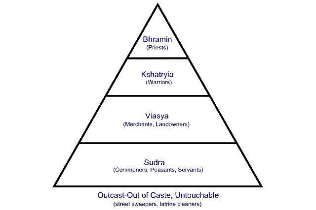
Caste System in India
500
an alliance involving 3 or more countries for their mutual benefit such as economic, cultural or political/ military
Supranationalism
500
Is a body of porous rock or sediment saturated with groundwater.
Aquifer
500
A force that brings people people towards the center (brings everyone together)
Centripetal Force
600
The Practice of Making Maps
Cartography
600
The limit that a location can support life due to factors such as food, shelter, water, etc.
Carrying Capacity
600
does not show any topographic features. It instead focuses solely on the state and national boundaries of a place. They also include the locations of cities - both large and small, depending on the detail of the map
Political Map
600
Region from which innovations or innovative ideas originate
The term "ay ay" before it spread
Hearth
600
an organization of independent states formed in 1945 to promote international peace and security
United Nations
600
The process by which commodities, people, and diseases crossed the Atlantic between 1500-1650
Columbian Exchange
600
The systematic killing of substantial numbers of people on the basis of ethnicity, religion, political opinion, social status, or other particularity Acts committed with intent to. destroy, in whole or in part, a national, ethnic, religious , or racial group
Genocide
700
19th-20th Century ideology that the environment caused human activity. Environment determines how life happens
Environmental Determinism
700
The total number of live births in a year for every 1,000 people alive in the society
Crude Birth Rate
700
Like a physical map. It differs in that this map uses contour lines to show elevation changes
What is Topographic Map
700
The sense of identity derived from a place through the meaning, ethnicity, culture etc. of that place
"Grandma's house"
Sense of Place
700
a political and economic community of twenty-four member states with supranational and intergovernmental features, located in Europe
European Union
700
is the destruction of forest or forested areas by human or natural means.
Deforestation
700
a neighborhood, district, or suburb which retains some cultural distinction from a larger, surrounding area
Ethnic Enclave
800
The Theory that the physical environment may set limits on human actions, but people have the ability to adjust to the physical environment and choose a course of action from many alternatives
Possiblism
800
A count of the population of a Nation, State or geographic region. In the U.S, this occurs every 10 years.
Census
800
shows things like the specific climatic zones of an area based on the temperature, the amount of snow an area receives or average number of cloudy days
What is a Climate Map
800
Notion that successive societies leave imprints on their place which influences future development
Sequence Occupancies
800
a geographical feature on land such as a valley, defile or a bridge, or at sea such as a straight which an armed force is forced to pass, therefore greatly decreasing its combat, in order to reach its objective.
Chokepoints
800
Land degradation in drylands
Desertification
800
The political term used when referring to the fragmentation or breakup of a region or country into smaller regions or countries
Centrifugal Force
900
The further and longer you are away from something, the less familiar you are with it
Distance Decay
900
The portion of Earth's surface occupied by permanent human settlement
Ecumene
900
map type that shows reference information for a particular place, making it useful for finding landmarks and for navigating. emphasis on location
Reference Map
900
The boundary line between two different linguistic regions
Isogloss
900
The movement of power from the central government to regional governments within the state or breakup of a large state into several independent ones
Devolution
900
Agriculture that Yields a large amount of output per acre
Extensive Agriculture
900
The political term used when referring to the fragmentation or breakup of a region or country into smaller regions or countries
*Usually reserved for Eastern Europe*
Balkanization
1000
The Ratio between the size of something and a representation of it
Scale
1000
The percentage growth of a population in a year, computed as the crude birth rate minus the crude death rate
NIR
Natural Increase Rate
1000
type of map that displays one or more variables such as population, or income level- within a specific area
Thematic Map
1000
The dominant language in a global or regional setting where different languages may exist
Lingua Franca
1000
To divide (a geographic area) into voting districts so as to give advantages to one party in elections
Gerrymandering
1000
A region of the Middle East that was particularly fertile several thousand years ago
Fertile Crescent
1000
a legal system that was the physical separation of different races into. different geographic areas
This resembles the U.S Segregation known as Jim Crow Laws
Apartheid
1100
A map projection that shows a larger geographic area with few details on it.
Small Scale
1100
money migrant send back to family and friends in their home countries, often in cash, forming an important part of the economy in many poorer countries
Remittances
1100
thematic map that uses tones or colors to represent spatial data as average values per unit of data
Choropleth Map
1100
A religion that attempts to be global or appeal to all people
Universalizing Religion
1100
areas with little or no access to healthy and affordable food or limited or no access to fresh fruits and vegetables
Food Desert
1100
Crops that produce more food per farming cycle than other wild varieties
High-Yield Seeds
1100
A nationality that is not represented by a state.
Stateless Nation