'X' Marks the Spot
Soooo Many Different Lenses
Unit 3
Definitions
100
Who were the first people to create representations of the Earth that reached beyond their own environment?
The Ancient Greeks
100
This type of geography is concerned with the study of people, their movements, settlements and activities.
Human Geography
100
A ____________ is a stable set of individuals, living together long enough to reproduce. Social, political, ethnical or religious characteristics can have an influence on them.
Population
100
_____________ is the discipline that is concerned with representing territories by means of the creation and interpretation of geographical maps.
Cartography
200
Who created this map?

Ptolemy
200
This field of geography is concerned with the study of all aspects of the natural environment.
Physical Geography
200
The _________ is the total number of births per 1000 inhabitants that occur during a year in a particular place.
birth rate
200
______________ maps offer representations of the Earth that show a group of characteristics which are very varied.
General maps
300
Two fundamental aspects of map reading are map _______________ and _________.
Map projection and scale.
300
This type of geography is concerned with how regions are organized and how they relate to each other.
Regional Geography
300
Deserts, rainforests, boreal forests, cold and hot desert areas, mountainous areas, and intensive agricultural and livestock areas are all examples of what?
Low-density areas: areas with lower population densities.
300
____________ maps show the spatial distribution of specific aspects of the land.
Thematic maps
400
This type of map projection:
- Represents the whole world
- Uses Equator as reference
- Deformations at the poles
Cylindrical projection

400
Who are the 'fathers' of Geography?
Alexander von Humboldt and Carl Ritter.
400
_______________________ is the difference between births and deaths, and is expressed as a percentage. This percentage shows if a population is growing, stable or decreasing in size as well as the rate at which it does so.
Natural population growth
400
This shows us the proportional relationship existing between what is represented on a map and reality.
A scale.
*Bonus points for telling us how a scale is expressed*
500
This type of map projection:
- Coverts meridians into straight lines that start at the pole
- Converts parallels into concentric circles
- Only represents one hemisphere at a time
Conical projection

500
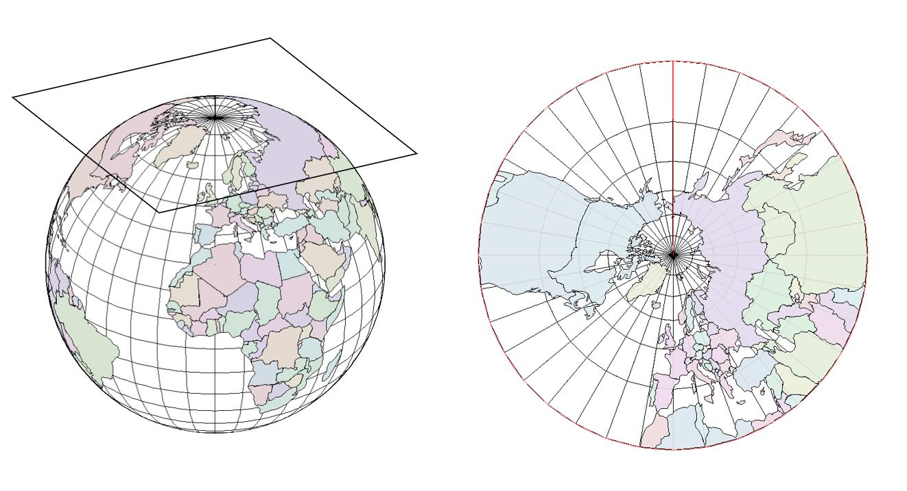
This type of map projection:
- Creates a circle around its central point that becomes a reference between the map and the sphere
- Generally uses one of the poles as its reference point
- Can only represent one hemisphere at a time
Flat projection
500
What is the difference between an emigrant and an immigrant?
Emigrant: someone who leaves their own country in order to settle permanently in another.
Immigrant: a person who comes to live permanently in a foreign country.
500
The network of imaginary lines drawn on maps / globes are known generally as _____________ _____________; and more specifically as _____________ and _____________ lines.
Geographic coordinates; latitude and longitude lines