The Law of the Land
Tools & Equipment
Maps, Math & Money
The Caribbean Built Environment
Built Environment General Knowledge
100
This legal concept refers to the rights a person has over a piece of land, including the right to use, sell, or lease it.
What is Real Property (or Real Estate)?
100
Before entering any active construction site, everyone must wear this specific acronym for (PPE) to ensure their safety. What is it?
Personal Protective Equipment
100
If a map has a scale of 1:100, and the distance on the map is 5 cm, what is the actual real-world distance in meters?
What is 5 meters? (5 cm × 100 = 500 cm = 5 m)
100
Founded in 1692 after a massive earthquake destroyed nearby Port Royal, this bustling harbor city on the southeastern coast serves as Jamaica's political and commercial center.
What is Kingston?
100
This bright orange object, often used to block off dangerous areas or direct traffic on a construction site, is a symbol of safety and site management.
What is a Traffic Cone?
200
In Jamaica, this specific type of legal title guarantees absolute ownership of land, free from any doubt or challenge (as opposed to a "common law" title).
What is a Registered Title (or Torrens System)?
200
This precision optical instrument, mounted on a tripod, is used by surveyors to measure horizontal and vertical angles between points.
What is a Theodolite?
200
Surveyors and Planners often use this famous theorem to calculate the length of a boundary line that forms a right-angled triangle. What is the formula?
What is the Pythagorean Theorem (a² + b² = c²)?
200
Because of Jamaica's tropical climate, buildings in the Caribbean must be designed to withstand these violent tropical storms with high winds and heavy rain.
What are Hurricanes (or Tropical Cyclones)?
200
These iconic structures are famous examples of this type of very tall, continuously habitable building, which planners must carefully integrate into city skylines.
What is a Skyscraper?
300
This act of Parliament is the primary legislation in Jamaica that dictates how land can be developed, subdivided, and zoned by local authorities.
What is the Town and Country Planning Act?
300
While laser measures are common today, Quantity Surveyors and Surveyors still frequently use this long, retractable steel tool to measure distances on site.
What is a Measuring Tape (or Steel Tape)?
300

Surveyors, Planners, and Real Estate students all rely on this specific type of map that shows the natural and artificial features of an area, such as roads, rivers, and elevation, usually drawn to a large scale.
What is a Topographic Map?
300
When planning coastal developments in Jamaica, professionals must account for this phenomenon, which is the gradual rise in global sea levels caused by melting ice caps.
What is Climate Change (or Sea Level Rise)?
300
In urban planning, this term refers to the ease with which people can walk around a neighbourhood—often measured by how safe the sidewalks are and how close amenities are to each other.
What is walkability?
400
If a developer begins construction without the necessary approvals from the local authority, the parish council can issue this legal notice to immediately halt all work on the site.
What is an Enforcement Notice (or Stop Order)?
400
This general term refers to the heavy, diesel-powered machines (like excavators and bulldozers) used for earthmoving, trenching, and site preparation.
What is Heavy Equipment (or Earthmoving Machinery)?
400
In Real Estate Valuation, you need to calculate the Gross Profit of a development project. What is the formula?
What is Gross Profit = Total Revenue (or Sale Price) - Total Cost?
400
This Jamaican government agency is specifically responsible for regulating and approving major development applications and subdivisions across the island.
What is the National Environment and Planning Agency (NEPA)?
400
Planners and engineers design special lanes, stops, and schedules for this mode of shared transportation, which is essential for reducing traffic congestion in cities.
What is Public Transit (or Public Transportation)?
500
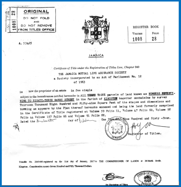
In Jamaica, this official document is the ultimate proof of land ownership and is guaranteed by the government under the Torrens system.
What is a Certificate of Title?
500
This simple site test uses a metal cone to measure the "workability" or consistency of fresh concrete before it sets.
What is a Slump Test?
500
This modern surveying technology uses a network of satellites to determine precise positions on Earth, and is abbreviated as GNSS.
What is the Global Navigation Satellite System (or GPS)?
500
In Caribbean coastal planning, this term refers to the physical and legal measures taken to prevent building in high-risk areas, such as flood zones or areas prone to landslides.
What is Setback (or Zoning Buffer)?
500
 In the built environment, we distinguish between the "Superstructure" (the building itself) and this term, which refers to the underlying systems like roads, water pipes, and power grids.
What is Infrastructure?