Map Skills
Landmasses/Oceans
Lines of the Earth
Geography
Tables
100
What is a compass rose used for on a map?
To tell directions/relative locations on a map
100
Name the largest continent on Earth.
Asia
100
What is latitude?
Lines moving north or south of the equator
100
What does a geographer study?
They study the characteristics and people on the earth
100
What type of information might you find in a population table?
How many people live in a place
200
How does a scale on a map help us?
It gives us the information to measure distances on a map
200
List all seven continents.
North America, South America, Europe, Asia, Africa, Australia, Antarctica
200
What is the Equator?
An imaginary horizontal line
200
How does culture affect geography?
People will typically move or segregate themselves based on language, food, customs.
200
How can graphs help us understand climate data?
How each climate zone is described, what a places climate is like
300
What do we call the symbols that represent features on a map?
Key
300
Identify the continent that is completely in the Southern Hemisphere.
![]()
Australia
300
What is the Prime Meridian?
An imaginary vertical line, creates timezones
300
What is one reason why understanding geography is important?
It can help you understand how to read a map, it can help you understand landforms, people, culture, government. Building blocks of science and history
300
What does a bar graph represent?
Represents data by using the length or height of rectangular bars to show numerical values for different categories
400
What is the purpose of a legend/key on a map?
Tells us information about the symbols on the map
400
What are the three oceans?
Pacific, Atlantic, Indian
400
What is the degrees of the pink dot? 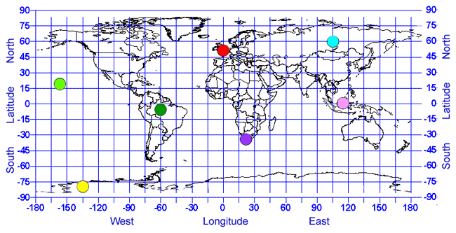
0, 115 E
400
How do we use geography in our daily lives?
Movement, location, place, human-environment interaction, region
400
Why is it important to read tables accurately?
To get the accurate information that you are looking for
500
Describe how to use latitude and longitude to find a location on a map.
It will give the absolute location on a map
500
Which ocean boarders the east coast of the U.S.A?
Atlantic
500
What is the degrees of the red?
47 N, 0
500
Describe how geographers use maps in their work.
As their tools to find information out about the place they are studying
500
How can comparing tables of different countries help us understand global issues?
You can visualize the differences in the countries and see compare their issues