Building up + wearing down
Natural Disasters And Climate Change
Rock Cycle
LOWERN/climate graphs
Landform Regions
100
This feature is commonly created by glacial erosion.
What is a u-shaped valley?
100
This is the place in Canada where hurricanes are most impactful.
Where is the Atlantic/East coast
100
What is an igneous rock?
Rock formed from cooled lava
100
These are the 6 factors affecting climate.
Latitude, ocean currents, wind, elevation, relief, nearness to water
100
This is the oldest mountain region in Canada
What is Appalachian mountains?
200
These 5 great things were caused by glaciation
What are the great lakes?
200
These are the two main Greenhouse Gases.
What are Carbon Dioxide and Methane?
200
What is a metamorphic rock?
Igneous or sedimentary rock formed from heat and pressure
200
This is how nearness to bodies of water impacts climate.
Higher overall precipitation, less variance in average tempurature/more moderate tempuratures.
200
This is the land form region in which we live
What is the Great Lakes and St Lawrence Lowlands
300
This is the difference between weathering and erosion
What is weathering breaks down and erosion moves?
300
Explain a climate change impact for each of the SEEP Perspectives
Social, economic, environmental, political
300
What is a sedimentary rock?
Eroded rock fragments that have settled, compacted and formed new rocks
300
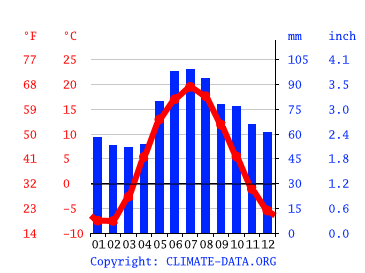 This image shows a (explain how you know)
continental climate (high temp variance, more precipitation in summer, low overall precipitation.
300
This is the landform region I would go to to watch my dog run for miles, mine oil, and farm in fertile soil
What is the interior plains?
400
Mountains are situated along these (be specific)
What are convergent tectonic plate boundaries?
400
Earthquakes are possible on either these two sites
What are plate boundaries and fault lines?
400
These very important things are only possible in one type of rock and this is how they got there.
What are fossil fuels being deposited in sedimentary rock?
400
This is what the windward and leeward side of the canadian rockies are like.
Wet, humid, warm (windward), & dry, cool (leeward)
400
This is the biggest landform region in Canada the age of the rock in it.
What is the Canadian Sheild and 1-4 billion years old (oldest)
500
At the mouth of a river these can be found-- this is what they are and how they were created
What are river deltas, built up through deposition
500
Go to the board! In less than 1m30s draw a diagram of the Human Enhanced Greenhouse affect
Ms. Dion will confirm
500
Go to the board! In 2 mins draw a perfect rock cycle.
Ms. Dion will approve.
500
Go to the board! In 1m30s draw a rough estimate for a climate graph in Vancouver BC
Ms. Dion will approve.
500
These are the three landform regions with mountains in Canada
What are the appalachians, the western cordillera an the innuitians?