What is Geography?
Latitude, Longitude, and Time Zones
Different Kinds of Maps
Immigration Throughout History
The Important Role of Rivers
Our Ever-Changing Earth
100
Why did most major cities develop along rivers?
What is, water is essential for drinking, cooking, bathing, farming, and transportation?
100
What does longitude measure?
What is the distance one is east or west of the prime meridian?
100
You might see this on a map. What is it called?
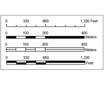
What is scale?
100
Define immigration.
What is moving from one country to another?
100
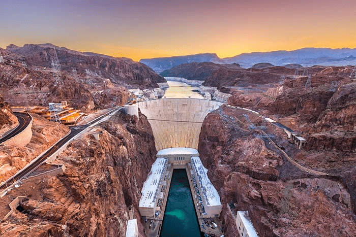
What was created between Nevada and Arizona in the 1930s? It was built to control floods, to supply water and power, and it also created Lake Mead.
What is the Hoover Dam?
100
What is the name of the infamous fault that lies in California?
What is the San Andreas Fault?
200
Why was Washington D.C. chosen as the country's capital?
What is, it was chosen to balance the interests of the North & the South?
200
What does latitude measure?
DAILY DOUBLE
What are lines of latitude also known as?
What is the distance north or south of the equator?
DAILY DOUBLE
What are parallels?
200
What is the main problem that faces map projections?
What is distortion?
200
What does it mean to push people into immigrating? Provide an example.
What is they are pushed to migrate due to hardships in their lives?
Some examples: The Irish Potato Famine (1845-1851) and the Dust Bowl (Great Plains 1931-1939).
200
What two major rivers did Lewis & Clark (1804 - 1806) take to get to the Pacific Ocean?
What are the Missouri and Columbia Rivers?
200
What created the Grand Canyon?
What is the Colorado River?
300
What are the four things that geography studies?
What is Earth's land, water, air, and living things?
300
How many time zones does Earth have, and how many degrees of longitude does Earth spin per hour?
What is 24 time zones and 15o (1 time zone) per hour?
300
What type of projection is this?
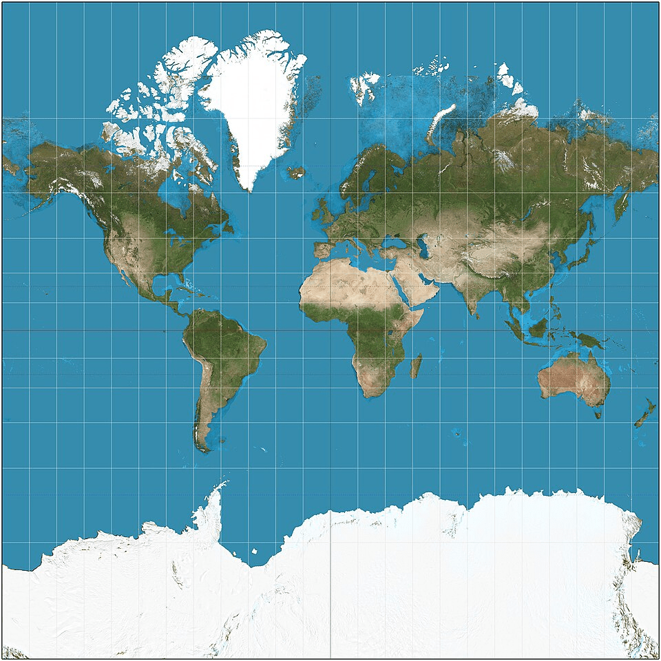
What is a Mercator projection?
300
What does it mean to pull people when talking about immigration? Provide an example.
What is they are pulled by opportunity that is present in the place they are immigrating to?
Some examples: Gold Rush (California 1849) and the building of the Transcontinental Railroad (1862-1869; met in Utah).
300
What is the longest river in the U.S.? What river holds the most water?
DAILY DOUBLE
What is the shortest river and where is it located?
What is the Missouri River? What is the Mississippi River?
DAILY DOUBLE
What is the Roe River in Montana?
300
What human process has led to Oklahoma's rise in earthquakes?
What is fracking?
400
What is the northernmost point and the southernmost point in the United States?
DAILY DOUBLE
What is the highest peak and lowest point in the United States?
What is Barrow, Alaska & Key West, Florida?
DAILY DOUBLE
What is Mount Denali (in Alaska) and Death Valley (in California)?
400
At what degree of longitude does the International Date Line run near - and what do you call those longitudinal lines?
What is 180o and they are called meridians?
400
What is a cartogram?
What is a map based on data, not the size of land?
400
What was the name of the land bridge that connected Asia to North America?
What is Beringia, the Bering Straight, or the Bering Land Bridge?
400
What is the name of the boundary that separates east-flowing rivers from west-flowing rivers?
What is the Continental Divide?
400
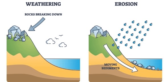
Define weathering and erosion.
What is weathering is the process of wearing down rock, while erosion is the process of moving rock/soil?
500
What is the difference between the Contiguous U.S. and the Continental U.S.?
You must include the states that are not included in each category as well.
What is contiguous are all connected states (not including Alaska or Hawaii) & continental are all North American states (not including Hawaii)?
500
What are the four time zones that the U.S. is a part of?
What are Eastern, Central, Mountain, and Pacific zones?
500
A _________ projection shows a map view from the pole with center point distances being accurate. Land areas are distorted however.
A _________ projection shows directions and distances that are less accurate, however land area is more accurate.
What is a plane projection and a Robinson projection?
500
Provide an example of forced migration, and an example of modern push and pull migration (as noted in the chapter).
What is enslaved African migration (1619 - 1859), what is Silicon Valley pull migration to tech companies in California (1975-2007), and what is New Orleans push migration after Hurricane Katrina (2005)?
500
What were the last names of the French explorers who became the first Europeans to explore the Mississippi River (1673)?
Who were Jolliet & Marquette?
500
What the Seven Natural Wonders?
What is the Grand Canyon, Mount Everest, Victoria Falls, Great Barrier Reef, Paricutin Volcano, Harbor of Rio de Janeiro, and the Northern Lights?