Atmosphere & Weather
Ocean Currents & Climate
Cells & Heredity
Energy & Convection
Earth Systems Maps
100
What type of front is shown by a red line with semicircles pointing in the direction of movement?
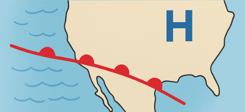
Heat Front
100
Is it possible to have a storm in the summer, if the Pacific Ocean water is cool if yes how so?
Yes, but there may be difficulty on how bad it is because they cannot gain energy from the cool water.
100
Which organelle contains the cell’s genetic material and controls cell functions? (Use the plant cell diagram labels.)
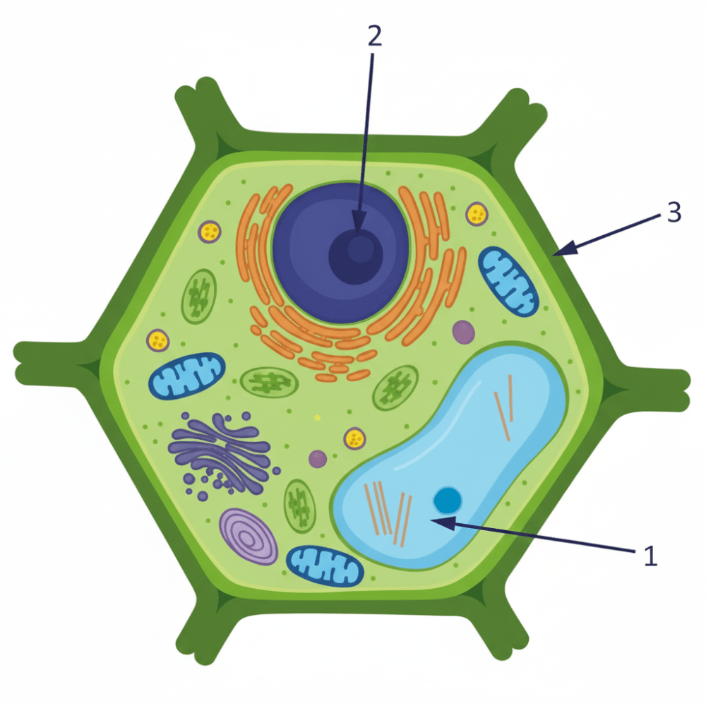
Contains the cell’s genetic material (DNA) and controls cell functions. #2

100
Which process (conduction, convection, or radiation) best describes the Sun heating ocean surface water and causing currents?
The Sun heats ocean water primarily through radiation, but this energy then drives convection within the ocean, causing currents as warmer, less dense water rises and cooler, denser water sinks, creating a continuous cycle that moves heat around the globe.
100
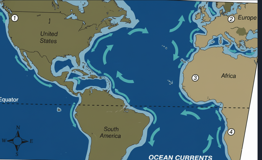
What does the dashed horizontal line labeled on the map represent?

he Equator.The dashed horizontal line at 0 degrees latitude.
200
Which weather symbol represents a high-pressure system on weather maps?

The Letter H
200
Warm ocean currents generally cause nearby coastal climates to become (warmer / cooler) and (wetter / drier).
Warm currents transfer heat and moisture to the air.
200
Which organelle is responsible for converting light energy into chemical energy (photosynthesis)?
Chloroplast Converts light energy into chemical energy (photosynthesis).
200
In the convection diagram of a heated pot, does warm water rise or sink?
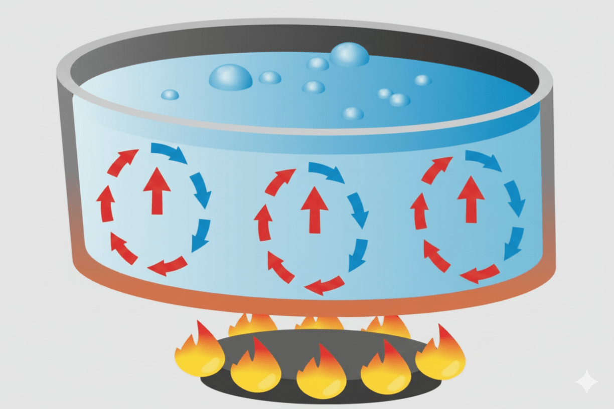
Because it is less dense than the surrounding cooler water it rises.
200
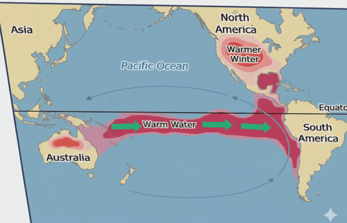
On the El Niño map, the warm water band moves east from which general region toward South America?

From near Australia / western Pacific toward South America (eastward). | The warm water sloshes eastward during an El Niño event.
300
When a warm front passes, temperature generally _____ and precipitation often _____ (fill in the blanks).
Temperature rises; precipitation often increases (or becomes steady/rain).
300
During El Niño, surface water temperatures in the central and eastern tropical Pacific are (higher / lower). How does this affect rainfall along the western coast of South America?
Surface water temperatures are higher; this causes increased rainfall and flooding along the western coast of South America.
300
List two observations from the cell data set that would most strongly indicate the cell is a plant cell.
cell wall and chloroplast
300
Explain how the Sun’s energy creates surface ocean currents that move warm water toward the poles.
The Sun heats equatorial surface water. This warm, less-dense water moves poleward as surface currents, while cooler, denser water sinks and returns as deep currents.
300
What climate effect is noted over North America during El Niño winters (from the provided map notes)?

Warmer winter (e.g., milder winters in some regions of North America).

400
Which city on the provided map most likely just experienced a warm front passing through it?
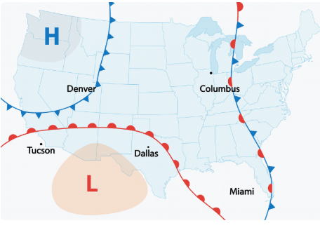
Colombus, Ohio
400
On the map of ocean gyres, which numbered location (1, 2, 3, or 4) is MOST likely to have a warmer climate than expected because of a warm current?

You must refer to the provided map: the answer is 1.
400
In bird flight, which inherited trait listed is most important: beak design, hollow bones, talons, or specialized eyes? Explain briefly.
They significantly reduce the bird's weight, which is critical for efficient flight.
400
Choose the correct pair: The Sun heats surface water causing it to (A) rise toward the poles or (B) rise toward the equator. Which is correct, and why?
Choice (A) is incorrect. The warm water moves toward the poles. The correct explanation is: The Sun heats surface water at the equator, and surface currents then transport this warm water toward higher latitudes (the poles).
400
Explain why warm equatorial surface currents moderate winter climates in Western Europe (short answer).
The Gulf Stream brings warm equatorial water north across the Atlantic, releasing its heat into the atmosphere and thus moderating Europe's winters.
500
Explain why Columbus (on an occluded front) is more likely than Denver or Seattle to have recently experienced a warm front passage.

An occluded front indicates a warm front preceded the occlusion. Columbus lies on the occluded front, so it likely experienced a warm front passage as the system evolved before or during the occlusion process.
500
Describe how differences in ocean salinity can contribute to deep water convection currents (brief explanation).
Differences in salinity change seawater density. Saltier, colder water sinks and drives thermohaline circulation (or Meridional Overturning Circulation - MOC), forming deep convection currents.
500
Define heredity in one sentence and name where genes are located inside a cell.
Heredity is the passage of genetic instructions from one generation to the next. Genes are segments of DNA located in the nucleus.
500
Explain why summer storms over the Pacific off the U.S. West Coast have difficulty intensifying when ocean surface temperatures are cool.
Cool surface waters reduce the energy available to the storms. Storms cannot intensify because they cannot draw sufficient latent heat energy from the cool ocean surface.
500
Given the Gulf Stream carrying warm water to Western Europe, choose the BEST answer from the list: Is this mainly caused by (A) the Sun heating oceans causing convection currents, (B) differences in ocean salinity causing deep water currents, (C) convection within Earth’s mantle, or (D) global wind patterns determining surface current direction? Explain your choice in one sentence.
(D) global wind patterns determining surface current direction. | Explaination: Global wind patterns (like the Westerlies and Trade Winds) are the primary force driving the direction and movement of the major surface ocean currents, including the Gulf Stream. (Though A is also a factor, D is the most accurate answer for the main cause of the direction.)