Land Formations
Weathering
Maps
Human Impact
Natural Disasters
100
This is the study of the Earth and what it is made of.
What is Geology?
100
True or False:
Weathering and erosion are the same thing.
What is false?
100
This type of map will help you to see the height of the land that you are looking at.
What is a topographic map?
100
Doing this with our plastic, aluminum, paper, and glass items will help reduce the number of things going into landfills.
What is recycling?
100
A tropical storm with winds reaching higher than 39 miles per hour is called what?
What is a hurricane?
200
What type of erosion caused the Devil's Tower National Monument to look like this?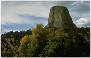
What is wind erosion?
200
This is the physical or chemical breakdown of rock.
What is weathering?
200
The four main points of the compass, north, south, east, and west, are also known as this.
What is cardinal direction?
200
Large whales and sharks get all wrapped up in these, placed in the ocean by fisherman to catch other fish, causing them to die.
What are nets?
200
This type of natural disaster is rated using the Fujita Damage Scale, or F-Scale.
What is a tornado?
300
Erosion that can move whole sand dunes and is a major cause of dust storms is called what?
What is wind erosion?
300
This is something that is broken down by weathering and erosion and you may find at the bottom of liquid.
What is sediment?
300
This line you don't see on the map separates the Earth's Eastern Hemisphere and Western Hemisphere.
What is the prime meridian?
300
Dams are often built to keep areas from flooding, but can also have a negative impact on the river's ecosystem. What is the change that creates this negative impact?
What is water temperature changes?
300
What are the three types of volcanoes?
What are cinder cones, shield volcanoes, and stratovolcanoes?
400
This is a type of rock that is formed from material that is settled into layers.
What is sedimentary?
400
What type of weathering has caused this?
What is chemical weathering?
400
You'll need to look at this on your map to determine what all the different symbols mean.
What is the legend?
400
These are created in the ozone layer which can allow harmful rays of the sun through.
What are holes?
400
These puzzle like pieces are a major cause of Earthquakes.
What are tectonic plates?
500
Acid rain creates this type of erosion on the land.
What is chemical erosion?
500
What are the three types of chemical weathering?
What are carbonation, oxidation, and hydrolysis?
500
This is the relationship between a distance on a map and the actual distance.
What is the scale?
500
Planting more trees means that more of this will be released into the environment.
Oxygen
500
Earthquakes and volcanoes can cause this natural disaster.
What is a tsunami?