Map Scale & Contour
Topographic Maps
Plate Tectonics
Random Category 1
Random Category 2
100
This is where we measure the distance on a map using physical measuring object such as a ruler.
What is Measured Distance?
100
This is something that every Topo Map includes at the bottom of their maps. What is the representative fraction of the map below?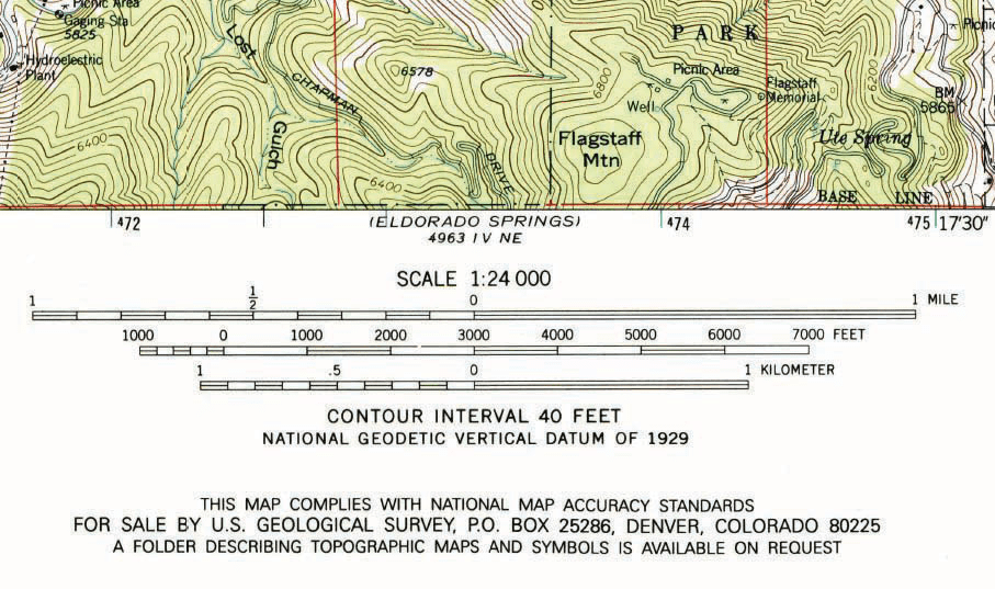
What is Map Scale and 1:24,000?
100
This type of plate boundary occurs when two plates slip laterally past one another.
What is Transform boundary?
100
These are lines drawn on a topographic map that connect points of equal elevation.
What is contour lines?
100
This is a volcanically active region that is caused by a mantle plume.
What is Hot Spot?
200
This is a geographic scale that pertains to a geographically restricted area, such as a city or a neighborhood.
What is Large scale perspective?
200
Every Topo Map will always have this in the northeast corner. Determine the name of this map. 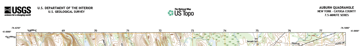
What is Auburn Quadrangle?
200
This plate is the biggest plate that is found on Earth.
What is the Pacific Plate?
200
This is the theory describing the origin, movement, and recycling of lithospheric resulting landforms.
What is Plate tectonics?
200
This is the process in which oceanic lithosphere of one plate bends and dives into the mantle beneath another plate.
What is subduction?
300
This map scale conveys the relationship between distance measured on a map and the actual distance that represents on Earth with a fraction or ratio.
What is Representative Fraction/Fractional Map Scale?
300
On a map with a scale of 1:24,000, a measured distance of 1 inch equals an actual distance of: [blank] feet. (1 foot = 12 inches)
What is 2,000 feet?
300
Convergent Oceanic to Continental boundaries form what type of boundary features?
What is a Volcanic Mountain Range and Ocean Trench?
300
These boundaries will have a mid-oceanic ridge with the age of the ocean floor increasing as the distance from the ridge increases along with shallow earthquakes.
What is divergent oceanic to oceanic boundary?
300
These plate boundaries will have a rift valley along with volcanoes and linear lakes.
What is divergent continental to continental boundary?
400
On a map with a scale of 1:30,000, a measured distance of 7.5 centimeters represents an actual distance of: [blank] meters. (1 meter = 100 centimeters)
What is 2,250 meters?
400
Some Topo Maps include a place where the elevation has been accurately determined and marked by a brass disc fixed to the ground.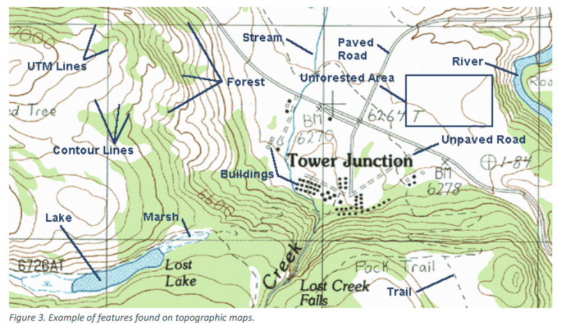
What is Benchmark?
400
At this plate boundary mountain building is occurring due to a process.
What is Continental-Continental Convergence and Collision?
400
Using the map below determine what the what the contour elevation is in the deepest part of the depression.
What is 375?
400
Using the map below determine the Relief of this map. 
What is 100?
500
Using the image below find the contour interval.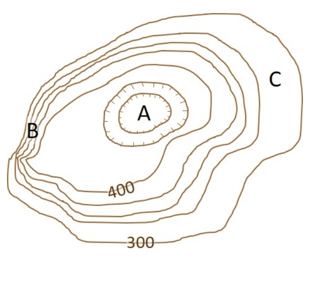
What is Contour Interval is 25?
500
When looking at USGS Topo Map what conclusions can be made about the map?
What is the map is 7.5 minutes of Latitude and Longitude?
500
This type of plate boundary will have a volcanic island arc, deep earthquakes, and oceanic trench to mark the boundary.
What is Convergent Oceanic to Oceanic Boundary?
500
Using the image below construct a topographic profile.

What is Answer Below?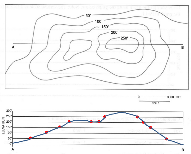
500
Using the image below determine the Vertical Exaggeration.
HS =
VS =
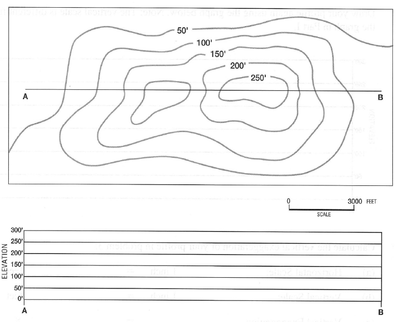
What is Vertical Exaggeration is 10x?