Geography
Map Skills
Map Terms
Globe Terms
Globe Skills
100
What is the study/science of the Earth's surfaces?
A) Geology
B) Government
C) Biology
D) Geography
D) Geography
100
What are the Cardinal Directions on a Compass Rose going clockwise?

North, East, South, West
100
What is a symbolic representation of an area of land or sea showing physical features?
A) Atlas
B) Map
C) Legend
D) Map Scale
B) Map
100
What is the half of the Earth that lies West of the Meridian?
A) Western Hemisphere
B) Equator
C) Eastern Hemisphere
D) Prime Meridian
A) Western Hemisphere
100
What is the number 1 on the globe depicting?
A) Prime Meridian
B) North Pole
C) South Pole
D) Equator
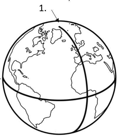
A) Prime Meridian
200
What is the world's main expanse of land?
A) Regions
B) Continents
C) States
D) Countries
B) Continents
200
What are the Intermediate Directions on the Compass Rose going clockwise?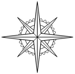
Northeast, Southeast, Southwest, Northeast
200
What is a circle showing the direction on a map or chart?
A) Atlas
B) Compass Rose
C) Map Scale
D) Coordinates
B) Compass Rose
200
What is an imaginary line around the Earth that is an equal distance from both poles?
A) International Date Line
B) Mercator Projection
C) Equator
D) Southern Hemisphere
C) Equator
200
What is the number 2 on the globe depicting?
A) Eastern Hemisphere
B) International Date Line
C) Western Hemisphere
D) Equator
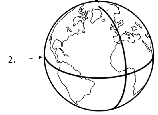
D) Equator
300
What deals with the natural features and processes?
A) Physical Geography
B) Geography
C) Geology
D) Human Geography
A) Physical Geography
300
What symbol represents where people would go to
camp?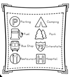
The park symbol
300
What is a key or symbols that appear on a map?
A) Map
B) Atlas
C) Compass Rose
D) Legend
D) Legend
300
What is the half of the Earth between the South Pole and Equator?
A) Northern Hemisphere
B) Mercator Projection
C) Southern Hemisphere
D) Prime Meridian
C) Southern Hemisphere
300
What continents are numbers 1-7 depicting?
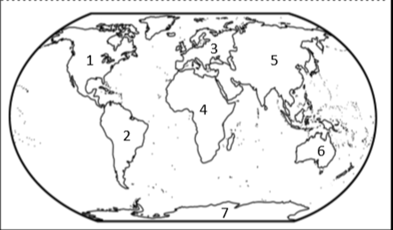
1) North America 2) South America 3) Europe
4) Africa 5) Asia 6) Australia 7) Antarctica
400
What deals with how activity affects the Earth's surface?
A) Geography
B) Human Geography
C) Physical Geography
D) Mercator Projection
B) Human Geography
400
If someone was needing transportation, what symbol would be helpful?

The bus stop symbol
400
What is a depiction of the geographic features of an area?
A) Globe
B) Political Map
C) Map Legend
D) Physical Map
D) Physical Map
400
What is an imaginary line that runs from the North to the South Pole?
A) Equator
B) Prime Meridian
C) Mercator Projection
D) International Date Line
D) International Date Line
400
What is the globe depicting below?
A) Latitude
B) Northern Hemisphere
C) Western Hemisphere
D) Longitude
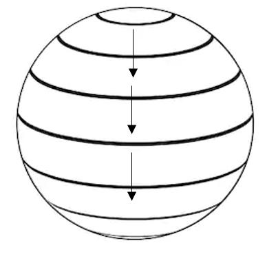
A) Latitude
500
What are the 5 themes of geography?
A) Latitude, Longitude, Compass, Legend and Map Scale
B) Location, Region, Direction, Place, and Human-Environment Interaction
C) Location, Physical, Region, Direction, and Human
D) Location, Place, Region, Movement, and Human-Environment Interaction
D) Location, Place, Region, Movement, and Human-Environment Interaction
500
What direction is the campfire of the sleeping tents?
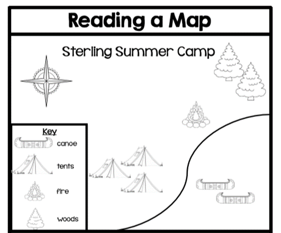
Northeast
500
What is a depiction of the geographic boundaries?
A) Political Map
B) Coordinates
C) Map Scale
D) Physical Map
A) Political Map
500
What divides the Earth into the Eastern and Western Hemisphere?
A) Eastern Hemisphere
B) International Date Line
C) Prime Meridian
D) Western Hemisphere
C) Prime Meridian
500
What is the globe depicting below?
A) Prime Meridian
B) Longitude
C) Southern Hemisphere
D) Latitude
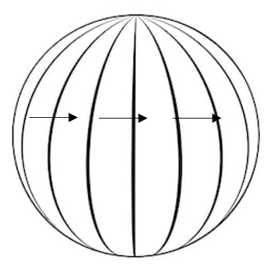
B) Longitude