Small Towns in BC
BC Geography
Gotta Love BC
Tricky BC Tourism
Fun BC Trivia
100
If you drive along Highway 3 from Princeton to Penticton, which of the following small towns are you going to go through?
1. Osoyoos
2. Merritt
3. Summerland
4. Keremeos
Answer: Keremeos
Keremeos has an annual rodeo and some of the best fruit stands you'll ever run across. It is right under K-mountain where rock slides form the first letter of its name.
100
Which of these towns is the farthest west on Highway 16 from Prince George?
1. Smithers
2. Hazelton
3. Burns Lake
4. Vanderhoof
Hazelton
Hazelton is also the one farthest north as the highway follows the Skeena River. Hazelton has an "old" town and a "new town", and is worth driving the extra miles from the others listed:)
100
Which is NOT a Gulf Island?
1. Salt Spring Island
2. Banks Island
3. Saturna Island
4. Mayne Island
Banks Island
100
Chemainus has become an important tourist attraction, why?
1. It houses the largest Canadian submarine.
2. It contains huge outdoor murals.
3. It is an underwater city.
4. Reindeer live in rainforests here.
It contains huge outdoor murals
The Chemainus mural project is the world's largest community-driven art project. Developed to save the community from economic collapse, the mural project has inspired and delighted millions of visitors and become the blueprint for community mural projects globally.
100
British Columbia's provincial mammal is a rare black bear with white fur. What is it called?
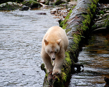
Image courtesy of Destination British Columbia.
1 Spirit Bear
2 Ghost Bear
3 Spirit Hunter
Spirit Bear
The rare Spirit Bear is also known as the Kermode Bear, named after Francis Kermode, former director of the Royal B.C. Museum, who researched this unique animal.
200
Which of these small towns is east of Fernie?
1. Rossland
2. Sparwood
3. Grand Forks
4. Cranbrook
Sparwood
Sparwood is the last stop on Highway 3 before the Crowsnest Pass and Alberta. If you have seen the coal port near the ferry terminal at Tsawwassen south of Vancouver, most of the coal comes by rail from places like Sparwood.
200
You should drive through which major town to get to Silver Start mountain and its ski resort?
Kelowna
Victoria
Merritt
Vernon
Vernon
200
Blackcomb Mt. doesn't have very much more room to expand because it backs on to which provincial Park?
Alice Lake
Brandywine
Golden Ears
Garibaldi
Garibaldi
200
A ferry able to hold 400 passengers links Vancouver and North Vancouver across Burrard Inlet, what is it called?
1. Puffin Ferry
2. SeaBus
3. Island Hopper
4. WaterTrain
Seabus
200
British Columbia has a lot of legends of mythical monsters and hairy beasts. Which one of these is a famous B.C. monster?
1 Sasquatch
2 Ogopogo
3 Jack-a-lope
4 All of the above
All of these are monsters that have reportedly been seen somewhere in British Columbia.
Sasquatch is said to be a large hairy man who lives in the forests of B.C.
Ogopogo is a lake monster that legend says lives in Lake Okanagan near Kelowna.
The Jack-a-lope is a horned rabbit-antelope mix you might run across as a trophy throughout B.C.
300
Which town is at Mile 0 of the Alaska Highway?
1. Chetwynd
2. Fort St. John
3. Dawson Creek
4. Fort St. James
Dawson Creek
Dawson Creek is the subject of many postcards showing the mileage from Mile 0 to many points along the Alaska Highway.
300
Which town is located in the Kootenays?
1. Princeton
2. Kitimat
3. Boston Bar
4. Fernie
Fernie
300
Which of these towns is not on the Sechelt peninsula?
1 Gibsons
2 Halfmoon Bay
3 Sechelt
4 Powell River
Powell River
Powell River is a ferry ride away from the Sechelt peninsula across Jervis Inlet. As isolated as the Sunshine Coast is -ie. the Sechelt peninsula - Powell River is off on its own. You need to take two ferries to get there from Vancouver, and only one from Comox on Vancouver Island.
300
Which of these towns is not on Vancouver Island?
1 Alert Bay
2 Port Hardy
3 Port McNeill
4 Kelsey Bay
Alert Bay
Alert Bay is on Cormorant Island, a ferry ride from Port McNeill. It was a stop on the shipping lanes of the 20s and 30s in the 20th Century and is home to the Nimpkish First Nations people. There is also a major hospital and aircraft landing strip on Cormorant Island.
300
How many time zones will you cross if you go from one end of British Columbia to the other end?
1 One
2 Two
3 Three
Two
Most of British Columbia follows Pacific Time, but some eastern parts of the province follow Mountain Time.
400
What is the place you drive through on the east side of Lake Okanagan to get to Kelowna from Penticton?
1. Vernon
2. Summerland
3. Naramata
4. Peachland
Naramata
it is also possible to get from Kelowna to Penticton on the west side through Summerland and Peachland.
400
Cruise ships going from Vancouver to Alaska sail north along this body of water.
1 Inside Passage
2 Puget Sound
3 Eastern Pacific
4 Northwest Strait
Inside Passage
The Inside Passages lies between Vancouver Island and the mainland.
400
Which of these is not the name of a town or hamlet in BC?
1 125 Mile House
2 100 Mile House
3 70 Mile House
4 150 Mile House
125 Mile House
All except 125 Mile House, which does not exist, are the stated distance from Lillooet BC as measured along the old Cariboo Trail. Of course, you could render this question wrong by pacing out 125 miles along the old Cariboo Trail and starting your own town!
400
Which of these three towns is the odd one out?
1 Sandspit
2 Queen Charlotte City
3 Masset
4 Tlell
Sandspit
All four are on the Queen Charlotte Islands - Haida Gwaii - but Sandspit is on the South Island. Masset is at the north end of the North Island, Queen Charlotte City is at the south end and Tlell is a jewel halfway in between.
400
Why does Vancouver have restrictions on the number of tall buildings that can be built in the city? (Hint: If you've been on any of John Atkins historical tours, you'll know this!)
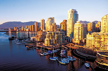
Image courtesy of Destination British Columbia
1 Laws were created to protect the views of the mountains, the ocean and the skyline
2 Safety concerns about fault lines and earthquakes
3 The soil isn't strong enough to support very tall buildings
#1 Laws related to scenic views
Vancouver has 27 protected "view corridors" in the city, each with a view of the mountains, the downtown skyline or the surrounding water. There are strict guidelines around how tall buildings can be in these areas, to make sure that the beautiful views aren't blocked!
500
Which town is the farthest east on the Trans Canada of those listed?
1. Revelstoke
2. Three Valley Gap
3.Invermere
4. Golden
Golden
Golden is the last major stop before heading into Alberta. You still have to go through Field BC at the bottom of the 'Big Hill' where a lot of trains wrecked before the Spiral Tunnel was put in at Kicking Horse pass.
500
Where is Mile 0 of the Trans Canada Highway located?
1 Duncan
2 Nanaimo
3 Tofino
4 Victoria
Victoria
Mile 0 is Located in Beacon Hill Provincial Park, in Victoria, at the very southern tip of Vancouver Island. Vancouver Island is 460 km long and 80 km wide.
500
Which of these towns is closest to the US border?
1 Grand Forks
2 Cranbrook
3 Prince Rupert
4 Bennett
Grand Forks
You had to consider Alaska to get this one, but Grand Forks is nestled almost at the 49th parallel. Highway 3 climbs some mountains to get there from Osoyoos because the natural valleys are all too far to the south.
500
Which small town has an even smaller town suburb called Canoe?
1 Kamloops
2 Sicamous
3 Enderby
4 Salmon Arm
Salmon Arm
Not exactly twin cities, but Canoe and Salmon Arm make quite a jewel on the Shuswap Lakes.
500
True or False: The Nanaimo bar is named after the city of Nanaimo, British Columbia.
1. True
2. False
It's true! This delicious dessert bar that you don't even have to bake is named after Nanaimo, B.C. There's a copy of a cookbook from 1953 in the Nanaimo museum that has the oldest known printed recipe for this wafer crumb-based bar with custard-flavoured butter icing and chocolate topping.