Map Language
Which Way?
Grid Lock
How Far?
Lat & Long
Who made this map?
100
Which part of a map tells you what each symbol means?
Key/Legend
100
Name the four main compass points, starting at north and going clockwise.
North, east, south, west.
100
In a four-figure grid reference, which number do you give first: the easting or the northing?
The easting (along the bottom) first.
100
What does a scale bar help you work out?
The real distance between places.
100
Which imaginary line divides the Earth into the Northern and Southern Hemispheres?
The equator (0° latitude).
100
When we treat a map as a source, what does its origin mean?
Who made it, and when.
200
On a map, a small blue triangle stands for a campsite. What do we call the blue triangle?
A symbol
200
Which direction is halfway between south and east?
South-east.
200
Give the four-figure grid reference for the well.
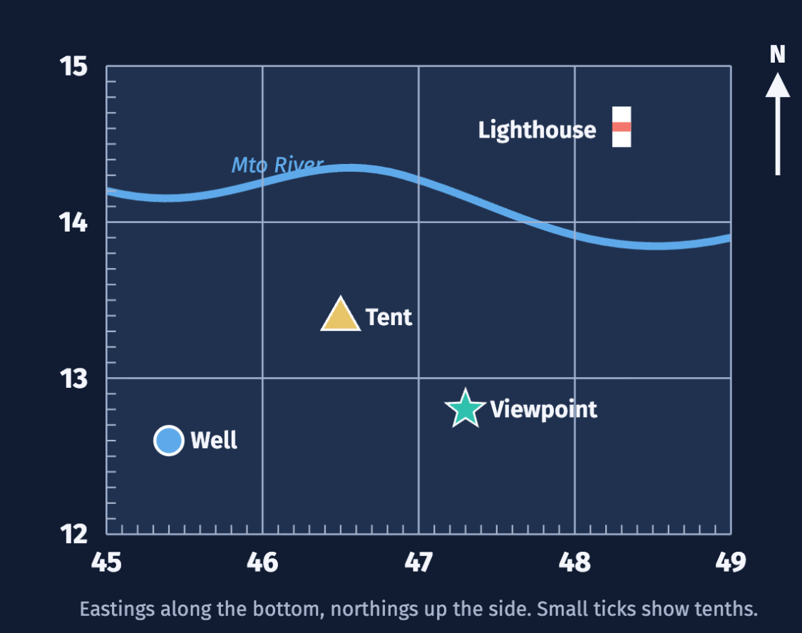
4512
200
On a map, 1 cm = 500 m. Two villages are 3 cm apart. How far apart are they in real life?
1,500 m (1.5 km).
200
Do lines of latitude run east to west, or north to south, across a map?
East to west.
200
What does a map's purpose mean?
Why it was made, and who it was made for.
300
Name one physical feature and one human feature you can see around our campus.
Physical: Kilimanjaro, a hill, a river, trees.
Human: a road, a building, a car park, a farm.
300
The library is north-east of the café. What direction is the café from the library?
South-west.
300
What can you find in square 4814?
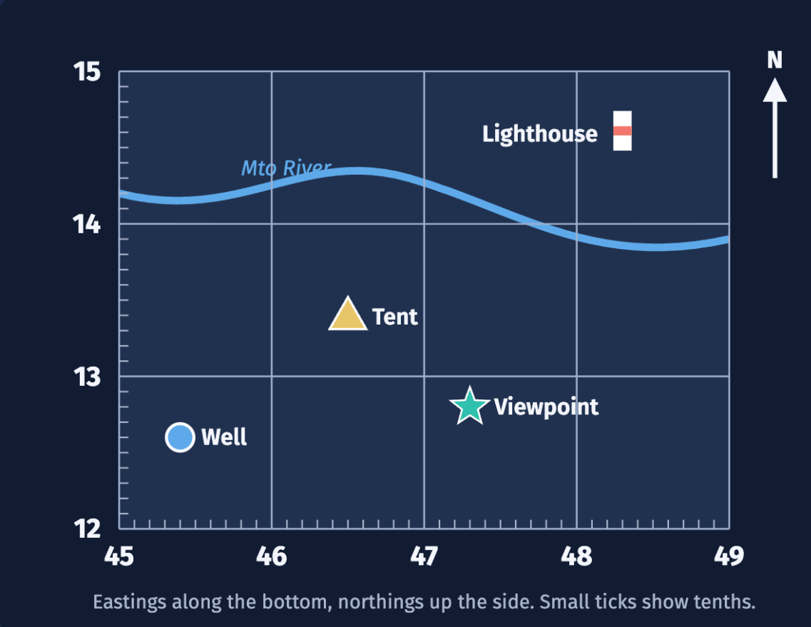
The lighthouse.
300
One grid square = 200 m. A path runs straight east across 4 grid squares. How long is the path?
800 m.
300
What is the name of the line of longitude at 0°?
The Prime Meridian.
300
A safari company makes a map of a national park for tourists. Name one thing it would probably show and one thing it might leave out.
Shows: lodges, viewpoints, animals to spot. Might leave out: dangers, closed roads, anything that puts visitors off.
400
Name three things every map should have so a reader can use it.
Any three of: title, key, scale, north arrow, grid.
400
Follow the route: School → Market → Clinic → Park. Give the direction for each step.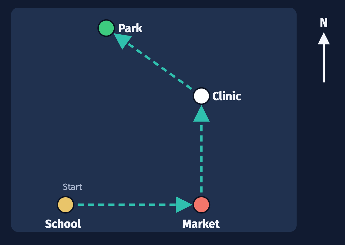
School to Market: east. Market to Clinic: north. Clinic to Park: north-west.
400
A student says the tent is in square 1346. What mistake did they make, and what is the correct reference?
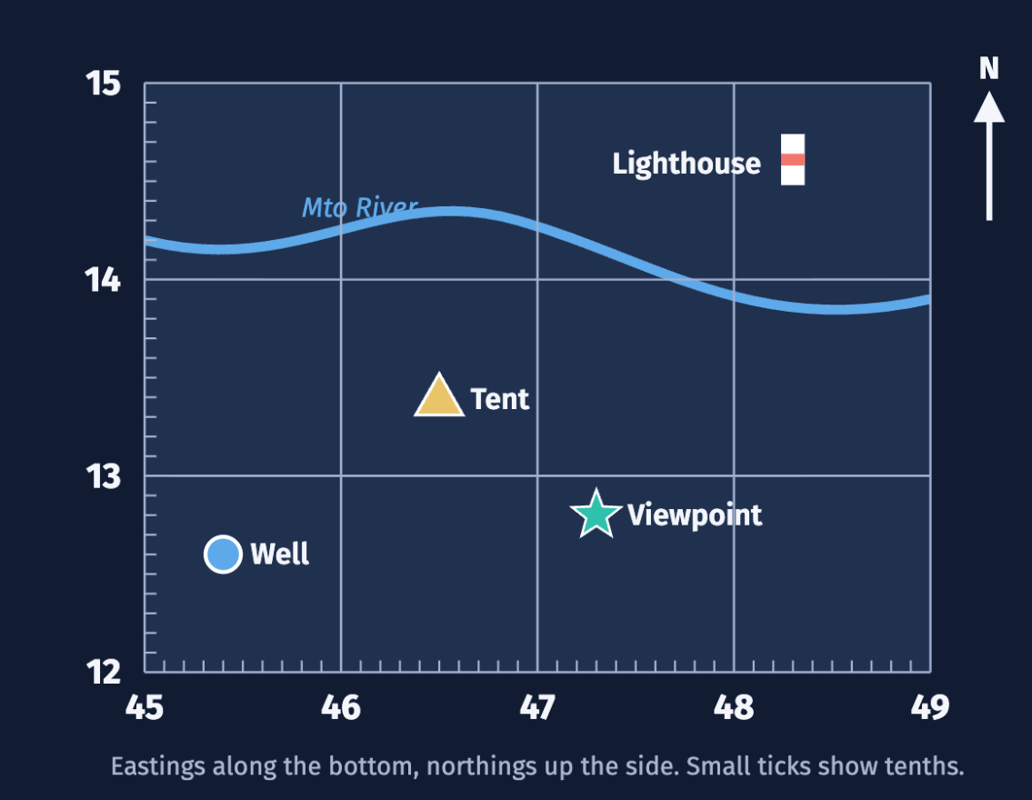
They gave the northing first. The correct reference is 4613.
400
The scale bar only shows 500 m, but two places are further apart than that. Explain how you could still measure the distance.
Mark 500 m on a strip of paper and lay it down more than once, or measure in cm and multiply.
400
Give the latitude and longitude of Lusaka, to the nearest whole degree. Latitude first.
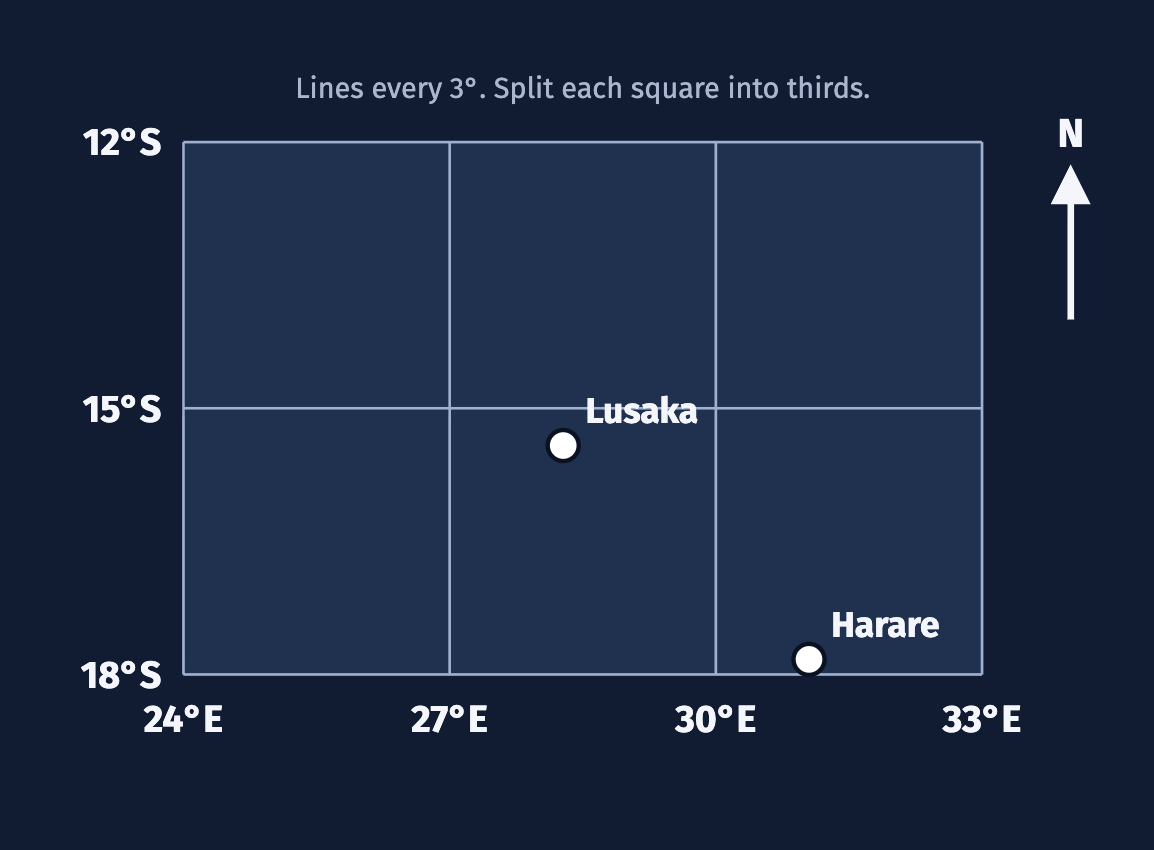
15°S, 28°E
400
A map of a city was made in 1960. Why might it not be reliable for finding your way today?
It is out of date: new roads and buildings are missing, and some places have changed.
500
Explain the difference between a map's key and its scale bar.
The key tells you what the symbols mean. The scale bar tells you how map distances compare to real distances.
500
Why does every map need a north arrow? Give one thing that could go wrong without it.
It shows which way the map faces, so you can read directions. Without it you could hold the map the wrong way and walk the wrong way.
500
Give the six-figure grid reference for the viewpoint (the star).
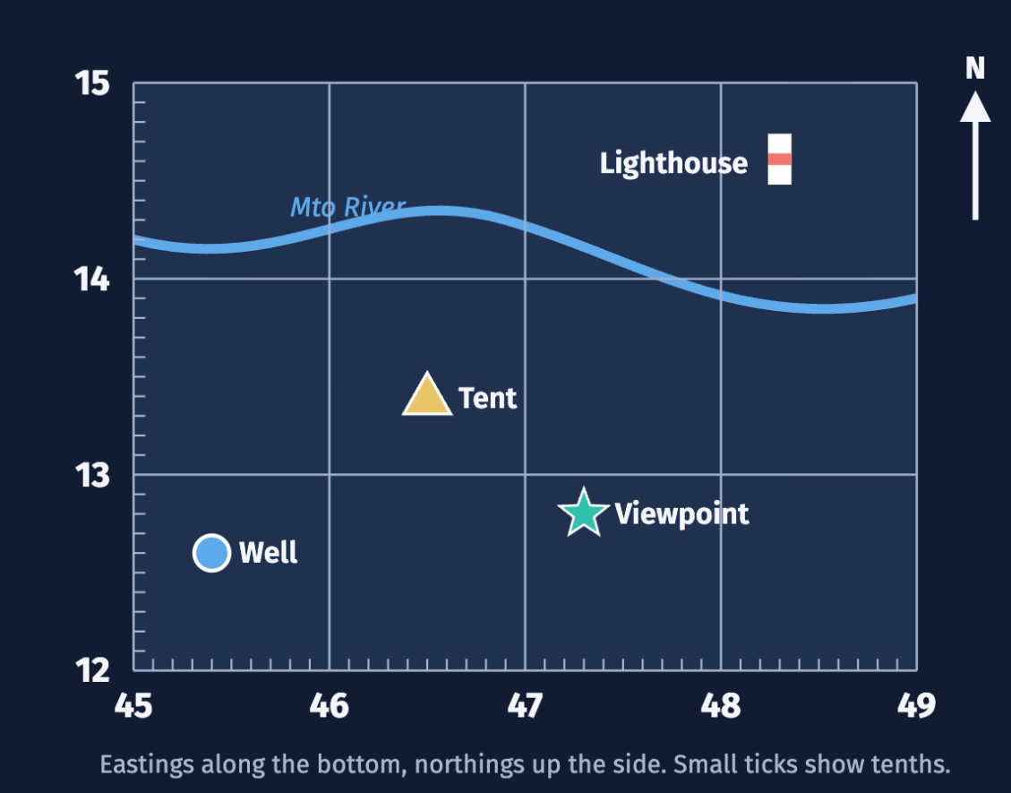
473128
500
On a map, 1 cm = 250 m. A trail is 6 cm long on the map. How long is it in kilometers?
1.5 km (6 × 250 m = 1,500 m).
500
Two cities have the same longitude but different latitudes. Where are they compared with each other?
One is directly north (or south) of the other.
500
A bus company and a cycling club both make a map of the same city. Which map would you use to plan a bike ride, and why?
The cycling club map, because it was made for cyclists, so it is more likely to show bike lanes, safe routes and hills.