Vocabulary in Disguise
Geography Made Me Do It
Prove It with Evidence
Map & Landmark Clues
Best Answer Traps
100
A person or group that moves from place to place with no permanent home.
a. What is nomadic?
b. What is sedentary?
c. What is adaptation?
d. What is resources?
What is A, nomadic?
100
This culture area lived near the Gulf Coast, bays, and marshes and used fish and shellfish as food resources.
a. Gulf Culture
b. Plains Culture
c. Puebloan Culture
d. Southeastern Culture
What is A, Gulf Culture?
Gulf Culture groups used coastal resources such as fish and shellfish.
100
A letter, diary, interview, artifact, or photograph from the time being studied.
A. primary source
B. secondary source
C. region
D. climate
What is A, primary source?
Evidence students can add:
A primary source comes from the time period or from someone directly connected to the event.
100
This Texas region has the Gulf Coast, bays, ports, humid climate, and many large cities.
A. Coastal Plains
B. Mountains and Basins
C. Great Plains
D. North Central Plains
What is A, Coastal Plains?
Evidence:
The Coastal Plains has Gulf access, rivers, ports, and large cities.
100
A question asks:
“Which evidence BEST supports the claim that the Coastal Plains had advantages for trade?”
A student chooses:
What is A — it explains farming better than trade?
Evidence students should give
Fertile soil and humid climate are real Coastal Plains clues, but trade is better supported by Gulf access, rivers, ports, and cities.
Why is this answer not the strongest evidence?
A. It explains farming better than trade.
B. It describes the Mountains and Basins region.
C. It uses an extreme word like always or never.
D. It proves the region had no natural resources.
What is A — it explains farming better than trade?
Evidence:
Fertile soil and humid climate are real Coastal Plains clues, but trade is better supported by Gulf access, rivers, ports, and cities.
200
An area of land grouped by shared characteristics such as climate, landforms, vegetation, or resources.
a. What is a resource?
b. What is geography?
c. What is a region?
d. What is agriculture?
What is C, region?
200
This culture area lived in East Texas forests with rivers and fertile land and built more permanent farming villages.
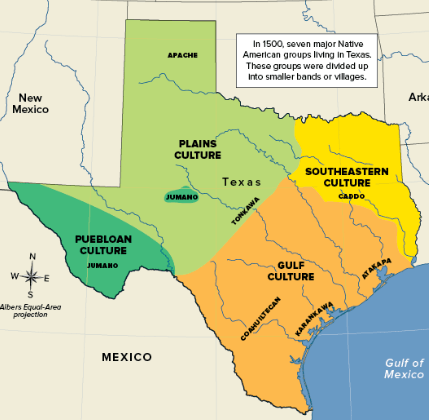
a. Gulf Culture
b. Southeastern Culture
c. Plains Culture
d. Puebloan Culture
What is B, Southeastern Culture?
Evidence:
Southeastern groups, including the Caddo, used rivers, forests, and fertile land for farming and villages.
200
A historian is studying this claim:
“The Caddo adapted to East Texas geography by farming and building more permanent villages.”
Which source would provide the strongest evidence for this claim?
A. An archaeological report describing farming tools, storage pits, and remains of permanent houses at a Caddo village site.
B. A textbook paragraph explaining that the Caddo were one of several American Indian groups that lived in Texas.
C. A museum caption showing Caddo pottery and explaining that the Caddo made useful and decorative objects.
D. A modern article explaining that the Caddo traded with other groups and had complex community traditions.
What is A?
Evidence students should give farming tools, storage pits, and house remains directly prove farming and permanent village life
200
This Texas region has mountains, basins, dry climate, rocky land, and limited water.
A. Coastal Plains
B. North Central Plains
C. Mountains and Basins
D. Great Plains
What is C, Mountains and Basins?
Evidence:
Mountains and Basins has mountains, desert basins, dry climate, and limited water.
200
A student is answering this question:
Which evidence BEST proves that the Coastal Plains had advantages for trade?
One answer says:
“The Coastal Plains had Gulf access, rivers, ports, and large cities.”
This is the best answer because it connects geography to this human activity.
A. farming
B. trade
C. mining
D. bison hunting
What is B, trade?
Evidence students should give
Gulf access, rivers, ports, and cities help explain movement of goods and people.
300
This word describes how people change their way of life to fit the land, water, climate, and resources around them. Must provide the answer and the evidence.
What is adaptation?
Evidence:
Adaptation means people adjust to their environment, such as farming near rivers or moving with bison.
300
A group lived on open grasslands where bison herds were an important resource. Explain the lifestyle choice that BEST fit this environment.
What is following bison herds and using portable shelters?
Evidence:
Open grasslands and bison herds made movement important, so portable shelters fit the environment.
300
A student is proving this claim:
“The Caddo adapted to East Texas geography by farming and building more permanent villages.”
The student says:
“The Caddo lived in East Texas.”
This is a true detail, but it is weak evidence. Give a stronger piece of evidence that better proves the claim.
What is rivers, forests, and fertile soil helped support farming and permanent villages?
Evidence students should give
The stronger evidence explains the full connection:
East Texas geography → farming → permanent villages
300
This Texas landmark is located in the Texas Panhandle and is known for canyon landforms and red rock layers.
What is Palo Duro Canyon?
Evidence:
Palo Duro Canyon is a canyon landmark in the Panhandle / Great Plains region.
300
A student chooses this answer:
“Mountains and Basins had many ports and rivers, so it supported large settlements.”
Explain why this answer is wrong, even though it uses geography words.
What is the geography clues are matched to the wrong region?
Evidence:
Mountains and Basins is known for dry climate, rugged land, mountains, basins, and limited water, not many ports and rivers.
400
This term means growing crops and raising animals for food. It helps explain why some groups built more permanent villages. Must provide the answer and the evidence.
What is agriculture?
Evidence:
Agriculture supports a more settled life because people stay near fields and food production.
400
Fill in the blank:
A group lived in a dry region near the Rio Grande. Rainfall was limited, but river water was available. Explain the adaptation that BEST helped this group farm.
What is using river water / irrigation to grow crops?
Evidence:
The dry climate made farming harder, so river water helped support crops.
400
A field note says:
“A group lived in a dry region where rainfall was limited. They lived near a major river and used water channels to move water to fields.”
This is the strongest evidence that the group adapted to a dry environment.
What is using river water channels / irrigation to grow crops?
Evidence:
Limited rainfall made farming harder, so using river water shows adaptation to the dry environment.
400
This underground water source helped people in the Great Plains farm and ranch even though the region had limited surface water.
What is the Ogallala Aquifer?
Evidence:
People used wells and windmills to bring underground water to the surface for farming and ranching.
400
A question asks:
Why was Location 1 near a river usually a stronger settlement choice than Location 2 far from reliable water?
A student answers:
“Rivers guaranteed that all nearby land would be easy to farm.”
Explain why this is a trap answer.
What is it uses a true idea too extremely?
Evidence students should give
Rivers can help with water, travel, farming, and trade, but they do not guarantee all nearby land is easy to farm.
500
This word describes the long-term pattern of temperature and precipitation in a place, not just today’s weather.
What is climate?
Evidence:
Climate is a long-term pattern, while weather is short-term.
500
Compare Gulf Culture and Plains Culture. Both groups moved, but they moved for different geographic reasons.
What is Gulf Culture moved with coastal resources, while Plains Culture moved with bison herds?
Evidence:
Gulf Culture used bays, marshes, fish, and shellfish. Plains Culture used open grasslands and bison herds.
500
A student makes this claim:
“Geography shaped how American Indian groups lived in different ways.”
Prove the claim using two culture areas. For each one, give:
1. the culture area
2. one geography clue
3. one effect on lifestyle
What are the differences between Gulf Culture and Plains Culture?
Gulf Culture lived near bays and marshes, so they fished, gathered shellfish, and moved with coastal resources. Plains Culture lived on open grasslands with bison, so they followed bison herds and used portable shelters.
500
A student says:
“Most large settlements developed more easily in areas with rivers, flatter land, and trade routes.”
Use map reasoning to explain why the Coastal Plains had stronger settlement and trade advantages than the Mountains and Basins.
What is the Coastal Plains had water access, rivers, ports, and flatter land, while Mountains and Basins had dry climate, rugged land, and limited water?
Evidence:
Coastal Plains geography supported:
- transportation
- trade
- farming
- larger settlements
Mountains and Basins geography made those harder because of:
- dry climate
- rugged land
- limited water
500
A question asks:
“Which evidence BEST proves that Puebloan groups adapted to a dry environment in far West Texas?”
Two students answer:
Student 1:
“They built adobe homes from sun-dried mud and straw.”
Student 2:
“They used river water channels to move water to nearby fields.”
Explain which student has the stronger answer and why.
Correct response
What is Student 2, because river water channels show how Puebloan groups solved the problem of limited rainfall?
Evidence:
Both answers are true, but Student 2 better proves adaptation to a dry farming environment:
limited rainfall → river water channels / irrigation → crops