Latitude and Longitude
Earth, Land, and Fire
Map Mania
Factors that Influence Climate
Random
100
North America can be found at 40 N latitude and 100 W longitude. This is an example of what type of "location?"
What is absolute location?
100
The rigid outer layer of Earth’s crust that uses external & internal forces to shape the Earth
What is the lithosphere?
100
A map that shows countries, cities, and other political units is best described as this type of map
What is a political map?
100
This climate region close to the poles is actually NOT an icy, frozen tundra, but instead hosts snowy pine tree forests in countries like Russia and Canada
What is the temperate climate zone?
100
Which month receives the hottest temperatures in Toronto, Canada? (shown below)
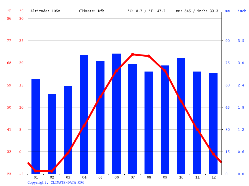
What is July? (Month 07)
200
What are the coordinates of point A? (remember North, South, East, and West)
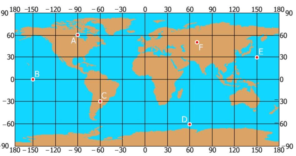
What are 60 N, 90 W?
200
This landform is mostly associated with "convergent boundaries" (except neither plate sinks down; they both just kind of bend)
What are mountains/mountain ranges?
200
The following map shows different sports fans all across the U.S. You know what type of "region" is shown here, but what is the type of MAP they're using?

What is a thematic map?
200
When the rain shadow effect occurs behind a mountain range, this word describes the side of the mountain that remains dry and deserted
What is the leeward side?
200
When rocks are broken down into smaller pieces
What is weathering?
300
Taylor High School is southwest of downtown Houston. This is an example of what type of "location?"
What is relative location?
300
This type of tectonic plate boundary happens when two plates slide past each other and cause earthquakes.
What is a transform boundary?
300
A central area connected by transportation & communication is called
What is a functional region?
300
This LAMECOW (shown below) tends to move in circular formations called "gyres"

What are ocean currents?
300
Weathering and erosion are primarily caused by these three forces of nature.
What are wind, water, and ice?
400
What are the coordinates of point D? (remember to use N, S, E, and W)
What is 60 S, 60 E?
400
This type of tectonic plate boundary is generally known to cause volcanic activity.
What is a subduction zone/boundary?
400
People think of a certain mental image when talking about "the Middle East," which may or may not be accurate. The Middle East is an example of a _____ region
What is a perceptual region?
400
Omaha, Nebraska has no nearby coastlines, whereas Houston, Texas is near the Gulf of Mexico. So, Omaha experiences a greater range of temperatures because of this LAMECOW
What is continentality?
400
The polar climate zone is generally the coldest place on Earth's surface, mainly because it gets the least of this natural resource

What is direct sunlight?
500
Which continent can be found at coordinates 30 S, 60 W?
What is South America?
500
Continental drift is used to explain the movement of continents resulting from the motion of...
What are tectonic plates?
500
This type of map shows us THE LANDFORMS

What is a physical map?
500
This picture best shows the effects of which LAMECOW?

What are mountain barriers?
500
Countries and other formal regions (with some form of government) are best shown on what type of map?

What is a political map?