Continents
Oceans/Hemispheres
Lines of Latitude/Longitude
Directions
Greater and Lesser Antilles-Windward /Leeward
100
Name the smallest continent.
Australia
100
Which of the FIVE OCEANS is closest to Trinidad and Tobago?
The Atlantic Ocean
100
Give another name for Lines of Latitude.
Parallels
100
Name the direction between West and South.
South West
100
True or False: Trinidad and Tobago is part of the Lesser Antilles
True: Trinidad and Tobago is part of the Lesser Antilles
200
Name continent 1 .
.
Antarctica
200
Name the Largest Ocean in the world.
The Pacific Ocean
200
Give another name for Lines of Longitude.
Meridians
200
What do we call the symbol that shows the directions on a map?
Compass Rose
200
Name a country that is part of the Greater Antilles.
Any of:
Cuba, Jamaica, Puerto Rico, Dominican Republic, Haiti and The Cayman Islands.
300
Name Continent 5.
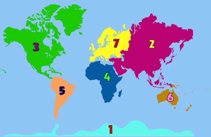
South America
300
What continent is in all 4 hemispheres?
Africa
300
What is the 00 line of Longitude that runs through Greenwich, England?
The Prime Meridian
300
The Directions North, South, East and West are called CARDINAL or ORDINAL directions?
CARDINAL
300
True or False: Trinidad and Tobago is part of the Leeward Islands.
False: Trinidad and Tobago is part of the Windward Islands.
Remember: The Windward Islands are generally more southern and are larger islands.
400
Continent 7 and 2 together are called one name - what is this name?

Eurasia
400
The majority of the world's population lives in which hemisphere?
Northern
400
What city is touching the 800W line?

Miami
400
What direction is the Treasure Chest FROM the Volcano?
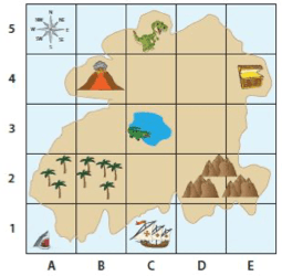
East
400
Name a Leeward Island.
The Leeward Islands are composed of the many smaller islands that make up the Lesser Antilles, including: Anguilla, Antigua, Barbuda, Guadeloupe, Montserrat, Nevis, Redonda, Saba, St. Barts, Saint Kitts, Saint Martin, Sint Eustatius, the British Virgin Islands, and the U.S. Virgin Islands.
500
About 300 million years ago, Earth didn't have seven continents, but instead one massive supercontinent called?
Pangea
500
What percentage of the Earth's surface is water?
71%
500
Name the two Lines of Latitude that RALEIGH falls between.
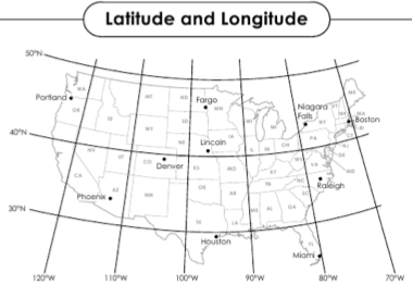
300N and 400N
500
What Direction are the TREES in the park FROM the Police Station?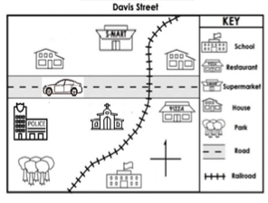
South
500
The name Windward Islands is fitting for those islands because....
These islands are on the path of the Northeastern trade winds.