Foundations of Geography
Think like a Historian
Early Humans/Stone Age
Mesopotamia
Mixed Bag
100
Measures the distance North or South of the equator that something is; DRAWN East to West
Latitude Lines
100
Provide three examples of a PRIMARY source.
1. Diary/Journal/Personal Notes
2. Speech or Interview
3. Autobiography
Others could be artifacts (tools/clothing)
100
Art of the nomadic Paleolithic people.
Cave Paintings and Carvings
100
The people of Mesopotamia were _____, and worshipped many god.
Polytheistic
100
What were the three eras of the Stone Age, in order from earliest to most recent?
Paleolithic, Mesolithic, Neolithic
200
Measures the distance east or west something is; DRAWN between the North and South poles
Longitude Lines
200
Provide three examples of a SECONDARY SOURCE.
1. Textbook or Encyclopedia Page (even Wikipedia)
2. Documentary
3. Student Essay
200
These were used during the Ice Ages to cross continents: a version of sheets of ice, or glaciers, that made human travel easier.
Land Bridges
200
Mesopotamian foothills were dry, forcing Mesopotamian farmers to settle on the plains between which two rivers?
Tigris and Euphrates
200
Agricultural Revolution resulted in food _____ which helped the population grow in the Neolithic age.
Surpluses
300
These two lines measure zero degrees: first the latitude zero and then the longitude zero
The Equator (latitude) and the Prime Meridian (longitude)
300
Put the following terms in order, from shortest time to greatest length of time.
Decade, Millennium, Century
Decade, Century, Millennium
300
This development/discovery moved Paleolithic nomads into the settled lifestyle of the Neolithic Era
Agricultural Revolution
300
The idea of equal punishment for the crime originated with ___________, the first set of laws which later influenced many cultures seeking fairness.
Hammurabi's Code
300
This development helped Mesopotamia grow, by watering crops consistently and preventing flooding.
Irrigation Systems
400
A map that shows the national boundaries of a disputed territory would be an example of this.
Special Purpose Map (Political Map)
400
In BCE and CE, the abbreviation CE stands for this.
Common Era
400
The first two ores combined to make usable metal tools, which kicked off the ______ age. Looking for three words.
Copper, Tin, Bronze
400
This is worlds oldest form of writing, and originated in Mesopotamia.
Cuneiform
400
This temple was built in a tiered-way, like a pyramid, up towards the gods so that priests could speak with them.
Ziggurats
500
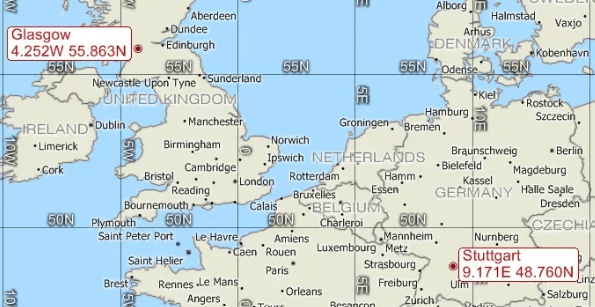
According to the map of Europe above, the best estimate for the coordinates of Hamburg, Germany.
Close to: 53.5 (or 54) degrees North, 10 degrees East
500
In BC and AD, AD stands for this.
Anno Domini
500
During the Neolithic age, people started to settle in _______ areas, now known as the birthplace of civilizations.
River Valleys
500
This Empire was the worlds first, after they conquered Sumeria, the city-state next door.
Akkad or Akkadians
500
The Sumerian King of legend that inspired the worlds first story, written in cuneiform.
Gilgamesh