4.1- 4.7
4.2
4.3
4.4
4.5
100
Name 4 types of political entities.
A state A nation A nation-state, A stateless nation, A A multinational state, A multistate nation, and autonomous and semi-autonomous regions, such as American Indian reservations.
100
To create a state need ......
A state has to have
Defined territory with borders
Permanent population
Government
Sovereignty: The right of a government to control and defend its territory and determine what happens within its borders.
Recognition from other states.
Defined territory with borders
Permanent population
Government
Sovereignty: The right of a government to control and defend its territory and determine what happens within its borders.
Recognition from other states.
100
Territoriality
Territoriality is the control and influence over a specific geographic space. It often includes aspects such as…
Historic and cultural links
Governments
Economics
Boundaries
Sovereignty
Defense/Military
Sometimes leads to conflict.
100
What is DMZ?
demilitarized zone
100
UNCLOS stands for what?
UNCLOS stands for what? The United Nations Convention on the Law of the Seas (1982)
200
Identify A nation-state get some examples.
A nation-state is when the borders of the nation match the borders of the state - a state with (ideally) only one nation within it.
No “true” examples
Japan 98% Japanese, 70% Shinto & Buddhist
Denmark 86.3% Danish, 75% Lutheran
Iceland 81% Norse/Celtic Heritage; 67% Lutheran
200
The meaning of Devolution
The meaning of Devolution Due to centrifugal forces, power is shifted from the central government or administration to regional authorities which are usually reflective of nations.
200
Neocolonialism
The use of economic, political, cultural or other pressures in order to control or influence other countries.
CORE -Semi-Periphery and Periphery Countries
200
Name types of political boundaries used by geographers.
Types of political boundaries include relic, superimposed, subsequent, antecedent,
geometric, and consequent boundaries.
200
Why China is building islands in the South China Sea
6 countries share the EZZ
300
Identify and get examples of A multinational state.
A multinational state is a country with various ethnicities and cultures within its borders. Examples: The United States, Russia, the former Yugoslavia, Iraq
300
Explain the degree to which the nation-state is the ideal political entity.
at a high degree because A nation-state consists almost entirely of one ethnicity with the self-determination to have sovereignty over a particular territory.
300
Shelterbelts
Instability within a region that is geographically located between states with overlapping territoriality and political power.
300
Antecedent boundaries/ example
Antecedent
Borders that are established before there has been major settlement by people in a territory.
Examples
49th parallel that separates the United States and Canada
300
Boundaries are defined, delimited, demarcated, and administered. means ...
Defined
Countries legally define and agree to where borders are located through an agreement or treaty.
Delimited
Identifying the location of the defined boundaries on a map. Usually at the same time that boundaries are defined and done through a legal designation.
Demarcated
Visible marking of the landscape with objects, such as fences or signs.
Administered
Legal management of the border through laws, immigration regulation, documentation, and prosecution.
400
What are the positive impacts of Federal governments?
Reduction of conflict around specific issues because each substrate can legislate differently.
Ex, Death penalty or legalization of marijuana
Local issues are resolved more quickly by regional/local governments.
400
What events have happened in the past that influenced the modern map?
1- Berlin Conference (1884)
2- The Treaty of Versailles (1920)
3- Establishment of Israel (1948)
4- Decolonization & Independence Movements (1945-1990)
5- Fall of the Soviet Union (1991)
400
What’s a Choke Point? Explain why these points are vital points and pose several risks at the same time, and get examples.
A strategic strait or canal that is narrow, hard to pass through, and has competition for use.
This could be closed or blocked to stop sea traffic and strategically show political power or territoriality.
400
Relic Border/ example
Relic
Border that no longer exists, but has left some imprint on the local cultural or environmental geography.
Examples: Boundary between East Germany and West Germany during the
400
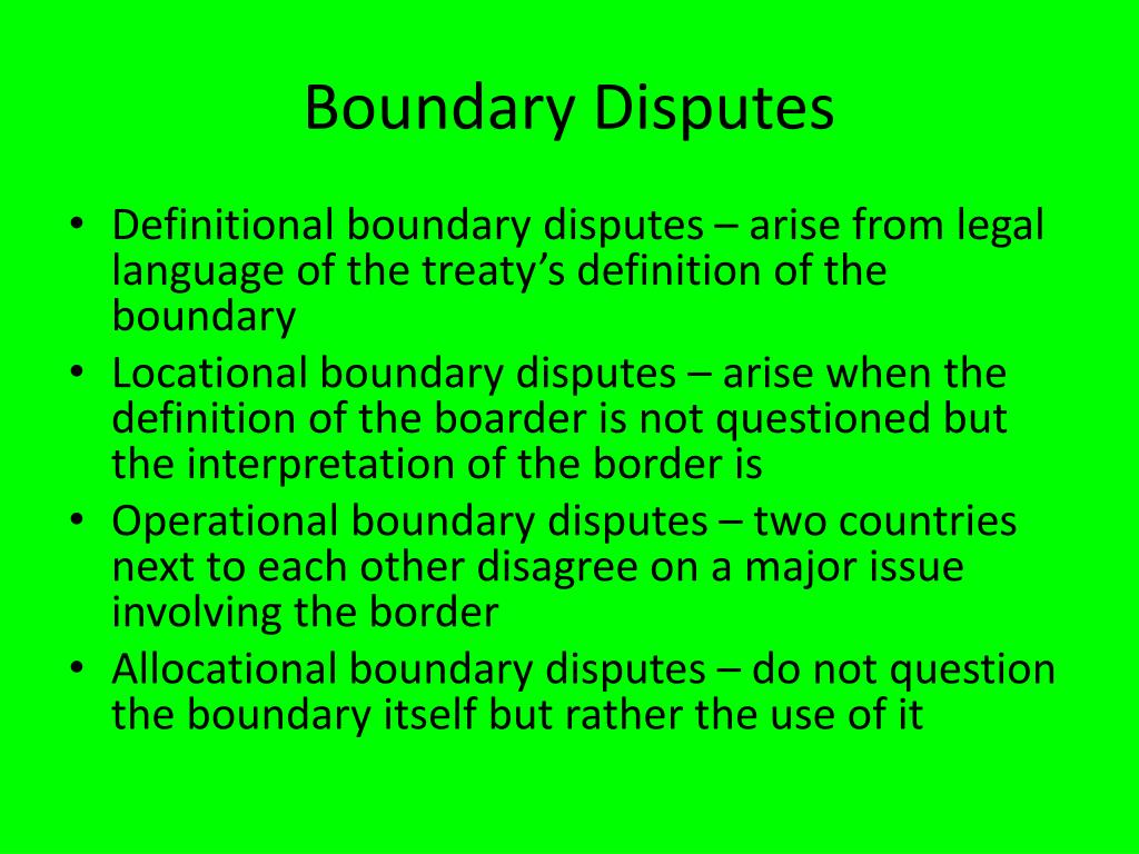
the boundaries disputes
500
Identify/get examples of Stateless nations
Stateless nations are nations of people without a state to occupy.
500
Identify the meaning of Self-determination.
The right of all people to govern themselves. Usually, a nation, ethnicity, or former colony wants to govern itself and establish sovereignty over its own state.
Oftentimes may result in independence movements or devolution.
500
Explain a likely economic effect of pilgrimages on the location shown in the Image.

free answers
500
Subsequent Borders& Consequent Boundary/ get an example
Subsequent
Borders are drawn in areas that have been settled by people, typically due to changes that have occurred over time. Boundaries in Europe
Consequent Type of subsequent boundary - takes into account the existing cultural distribution of the people living in the territory and redevelops boundary lines to more closely align with cultural boundaries.
Example:
The boundary between Nunavut and the rest of Canada - drawn in 1999, established a province that coincided with indigenous groups
500
The United Nations Convention on the Law of the Seas (1982)
Territorial Sea
- 12 nautical miles from the coastline
EEZ (Exclusive Economic Zone):
- 200 nautical miles A state has special rights over the exploration and use of marine resources such as fishing,
- High seas