According to this map, which numbered state has the highest population growth rate?
A.? 1
B.? 2
C. ? 3
D. ? 4
B.? 2

The structure in this photograph is most closely associated with the culture of which region?
A. ? Siberia
B. ? Southwest Asia
C. ? Europe
D.? North America
C. ? Europe

The site shown in this photograph is part of the cultural landscape of —
A. ? Southeast Asia
B. ? North Africa
C. ? Eastern Europe
D. ? Latin America
D. ? Latin America

What do these cities have in common?
A.? Harbor sites
B.? Mountainous peaks
C. ? Pilgrimage destinations
D. ? Government centers
C. ? Pilgrimage destinations

In which country would a clothing company most likely locate its
jeans factory?
A.? 1
B.? 2
C.? 3
D? 4
A.? 1

In which climate would this type of vegetation be found?
A. ? Tropical
B. ? Mediterranean
C. ? Tundra
D. ? Arid
D. ? Arid

Which city contains these three religious monuments?
A. ? Istanbul
B. ? Rome
C. ? Mecca
D. ? Jerusalem
D. ? Jerusalem

The darker-shaded region is a —
A. ? colonial province
B. ? neutral country
C. ? disputed territory
D. ? demilitarized zone
C. ? disputed territory

What is the main function of the darker-shaded region on this map?
A. ? Resource protection
B. ? Business development
C. ? Waste disposal
D.? Tourist attraction
A. ? Resource protection

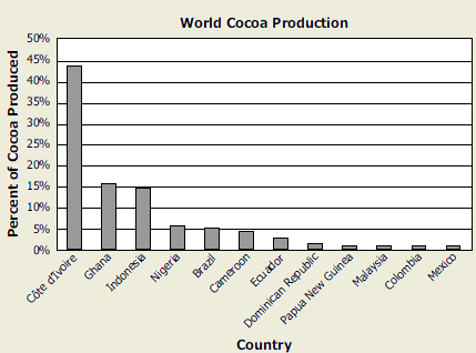
According to this graph, which region is the largest producer of cocoa?
A.? South America
B.? Central America
C.? West Africa
D. ? Southeast Asia
C.? West Africa

30°N, 120°E is located within the continent of —
A. ? Asia
B.? Europe
C. ? Australia
D. ? North America
A. ? Asia

Which of these is a correct addition to the table?
A.? Buenos Aires in Column A
B.? Sydney in Column A
C. ? Madrid in Column B
D. ? Toronto in Column B
D. ? Toronto in Column B

The main agricultural product in this geographic region is —
A. ? wheat
B. ? corn
C. ? rice
D. ? beans
C. ? rice

These nations are able to make these donations because they are —
A. military powers
B. the wealthiest in the world
C. the largest in the world
D. developing economies
B. the wealthiest in the world

Which phrase best completes this diagram?
A.? Low average age
B.? High average income
C.? High literacy rates
D. ? Low disease rates
A.? Low average age

Which South American country does NOT border the Pacific Ocean?
A ? Peru
B. ? Chile
C. ? Ecuador
D. ? Brazil
D. ? Brazil

Which region is described by this list?
A. ? Central America
B. ? Sub-Saharan Africa
C. ? Middle East
D. ? Scandinavian Peninsula
B. ? Sub-Saharan Africa

Which process is described by this diagram?
A ? Desertification
B ? Deposition
C ? Erosion
D ? Pollution
B ? Deposition

According to this map, in which of these countries are three different religions practiced?
A.? Laos
B.? Cambodia
C.? Thailand
D.? Malaysia
B.? Cambodia

Which list correctly ranks this country’s levels of economic activity from largest to smallest?
A. Primary, Secondary, Tertiary
B. Secondary, Tertiary, Primary
C. Secondary, Primary, Tertiary
D. Tertiary, Primary, Secondary
C. Secondary, Primary, Tertiary

This peninsula has been divided as the result of —
A. ? religious differences
B. ? a political dispute
C. ? a language barrier
D. ? physical characteristics
B. ? a political dispute

Which landform in the United States is most closely identified with the characteristics in this box?
A. ? Great Plains
B. ? Canadian Shield
C. ? Gulf Coast
D. ? Rocky Mountains
C. ? Gulf Coast

This graph supports the conclusion that the United States is reliant on the growth of —
A. ? city centers
B. ? airline travel
C. ? commuter railways
D. ? road construction
D. ? road construction

Based on this data, what is one reason the infant mortality rate is higher in Angola than in Botswana?
A. The population is greater in Botswana.
B. The literacy rate in Angola for males 15 to 24 is higher.
C. Fewer births are attended by skilled professionals in Angola.
D. Many of the women in Botswana are 50 and older.
C. Fewer births are attended by skilled professionals in Angola.

Which phrase best completes the title of this list?
A. ? Urban Areas
B. ? Free Trade Regions
C.? Integrated Neighborhoods
D. ? Regional Conservation Offices
A. ? Urban Areas