Terms
Parallels & Meridians
Basic Map Skills
The Five Themes
Reading Latitude & Longitude
Map Reading
100
The seven largest areas of land on Earth.
Las siete áreas de tierra más grandes de la Tierra.
What are continents?
¿Qué son los continentes?
100
This imaginary line is located at 0° latitude.
Esta línea imaginaria se encuentra a 0° de latitud.
What is the equator?
¿Qué es el ecuador?
100
This map component tells you which direction is north.
Este componente del mapa te indica en qué dirección está el norte.
What is the compass rose?
¿Qué es la rosa de los vientos?
100
This tells you where someplace can be found. It can be given in either absolute or relative terms.
Esto te indica dónde se encuentra un lugar. Se puede expresar en términos absolutos o relativos.
What is location?
¿Qué es la ubicación?
100
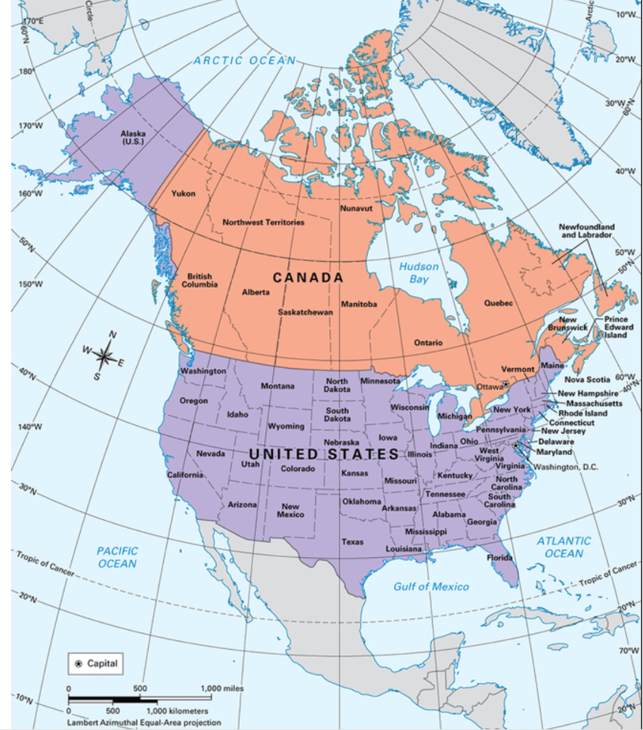
This state is located at 45°N, 100°W?
What is South Dakota?
100
This shows the relationship between a distance on a map and the corresponding distance on the ground.
Esto muestra la relación entre una distancia en un mapa y la distancia correspondiente sobre el terreno.
What is map scale?
¿Qué es la escala de un mapa?
200
It is where a place is located in relation to another place.
Es la ubicación de un lugar en relación con otro lugar.
What is relative location?
¿Qué es la ubicación relativa?
200
This imaginary line marks 0° longitude and runs through Greenwich Observatory in London, England.
Esta línea imaginaria marca los 0° de longitud y atraviesa el Observatorio de Greenwich, en Londres, Inglaterra.
What is the Prime Meridian?
¿Qué es el meridiano cero?
200
Consisting of a series of horizontal and vertical lines, this map component helps a reader find absolute locations.
Compuesto por una serie de líneas horizontales y verticales, este componente del mapa ayuda al lector a encontrar ubicaciones absolutas.
What is the map grid?
¿Qué es la cuadrícula del mapa?
200
This theme involves grouping areas together according to unifying characteristics.
Este tema consiste en agrupar áreas según características comunes.
What is region?
¿Qué es una región?
200
 This country is located at 60°N, 120°W?
What is Canada?
200
- Map Scale: 1 inch = 10 miles
- The distance between two cities on a map is 3 inches, so this is the actual distance between the cities in miles.
Escala del mapa: 1 pulgada = 10 millas
La distancia entre dos ciudades en un mapa es de 3 pulgadas, por lo que esta es la distancia real entre las ciudades en millas.
What is 30 miles?
¿Qué son 30 millas?
300
This is a person who studies the physical features of the Earth, and how humans interact with their environment.
Es una persona que estudia las características físicas de la Tierra y cómo los seres humanos interactúan con su entorno.
What is a geographer?
¿Qué es un geógrafo?
300
This imaginary line is located at about 66.5° south latitude and marks the northern edge of the southern polar zone.
Esta línea imaginaria se encuentra a unos 66,5° de latitud sur y marca el límite norte de la zona polar sur.
What is the Antarctic Circle?
¿Qué es el círculo polar antártico?
300
This map component shows what symbols and colors on a map are meant to represent.
Este componente del mapa muestra qué simbolos y colores del mapa representan.
What is a map legend, or key?
¿Qué es una leyenda o clave de un mapa?
300
This theme studies how the environment impacts people, and how people impact the environment.
Este tema estudia cómo el medio ambiente afecta a las personas y cómo las personas afectan al medio ambiente.
What is human-environment interaction?
¿Qué es la interacción entre el ser humano y el medio ambiente?
300
 This country is located at 20°, -100°?
What is Mexico?
300
- Map Scale: 1 inch = 5 miles
- The distance between two landmarks on a map is 4.5 inches, so this is the actual distance between the landmarks in miles.
Escala del mapa: 1 pulgada = 5 millas
La distancia entre dos puntos de referencia en un mapa es de 4,5 pulgadas, por lo que esta es la distancia real entre los puntos de referencia en millas.
What is 22.5 miles?
¿Qué son 22,5 millas?
400
A person who creates maps.
Una persona que crea mapas.
What is a cartographer?
¿Qué es un cartógrafo?
400
This imaginary line is located at about 23.5° north latitude and marks the southern edge of the northern temperate zone.
Esta línea imaginaria se encuentra aproximadamente a 23,5° de latitud norte y marca el límite sur de la zona templada septentrional.
What is the Tropic of Cancer?
¿Qué es el Trópico de Cáncer?
400
These are the seven continents.
Estos son los siete continentes.
What are North America, South America, Europe, Asia, Antarctica, Africa, and Australia?
¿Qué son América del Norte, América del Sur, Europa, Asia, la Antártida, África y Australia?
400
This theme describes the human and physical characteristics of a location.
Este tema describe las características humanas y físicas de un lugar.
What is place?
¿Qué es el lugar?
400
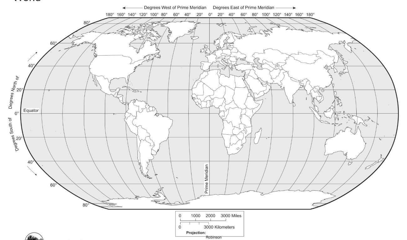 This continent is located at -10, -50?
What is South America?
400
Map Scale: 1 inch = 30 miles
The distance between two cities on a map is .5 inches, so, this is the actual distance between the cities in miles.
Escala del mapa: 1 pulgada = 30 millas
La distancia entre dos ciudades en un mapa es de 0,5 pulgadas, por lo que esta es la distancia real entre las ciudades en millas.
What is 15 miles?
¿Qué son 15 millas?
500
The change in the shape, size, or position of a place when it is shown on a map.
El cambio en la forma, el tamaño o la posición de un lugar cuando se muestra en un mapa.
What is distortion?
¿Qué es la distorsión?
500
This imaginary line is located at 180° longitude. Travelers who cross over it will find that the date on their phones has changed.
Esta línea imaginaria se encuentra a 180° de longitud. Los viajeros que la crucen verán que la fecha de sus teléfonos ha cambiado.
What is the International Date Line?
¿Qué es la línea internacional de cambio de fecha?
500
These are methods used by cartographers to compensate for distortion when displaying the globe on a flat map.
Estos son métodos utilizados por los cartógrafos para compensar la distorsión al representar el globo terráqueo en un mapa plano.
What are map projections?
¿Qué son las proyecciones cartográficas?
500
This theme examines how and why people, goods, and ideas are transferred from one place to another.
Este tema examina cómo y por qué las personas, los bienes y las ideas se transfieren de un lugar a otro.
What is movement?
¿Qué es el movimiento?
500
North America is located in these hemispheres.
América del Norte se encuentra en estos hemisferios.
What are the northern and western hemispheres?
¿Qué son los hemisferios norte y oeste?
500
A map has a scale of 1 inch = 10 miles. The actual distance between two cities is 50 miles. This is how far apart are the cities are on the map.
Un mapa tiene una escala de 1 pulgada = 10 millas. La distancia real entre dos ciudades es de 50 millas. Esta es la distancia que hay entre las ciudades en el mapa.
What is 5 inches?
¿Qué son 5 pulgadas?