4.1 Plate Tectonics
4.2 Soil Formation & Erosion
4.3 Soil Composition & Properties
4.4 Earth's Atmosphere
4.5 Global Wind Patterns
4.6 Watersheds
4.7 Solar Radiation & Earth's Seasons
4.8 Earth's Geography & Climate
4.9 El Nino and La Nina
100
What is the mechanism behind pate tectonic movement?
Convection
100

___________ is the starting point for most soil development and is the basic geological material in a particular location.
A. Bed Rock
B. Parent Material
C. Silt
D. Sand
B. Parent Material
100
Which soil particle is largest in diameter?
A. Clay
B. Silt
C. Sand
D. Loam
C. Sand
100
In which layer of the atmosphere does weather take place?
A. Troposphere
B. Stratosphere
C. Mesosphere
D. Thermosphere
E. Exosphere
Troposphere
100

Which of the following is a biome found at the equator?
A. Rain forests
B. Tundras
C. Coniferous forests
D. Deserts
A. Rain forests
100
An area of land that drains all the streams and rainfall to a common outlet such as the outflow of a reservoir, mouth of a bay, or any point along a stream channel.
Watershed
100
Earth's Main source of energy.
Solar Radiation from the Sun.
100
As altitude increases, what happens to temperature?
A. Temperature increases
B. Temperature decreases
C. Temperature does not change with altitude
B. Temperature decreases
100
This brings cold, rich nutrients to the surface and it also Increases fish productivity.
Upwelling
200
A Plate Boundary where two plates move toward each other is called
A. Convergent Boundary
B. Divergent Boundary
C. Transform Boundary
D. Subduction
A. Convergent Boundary
200
The type of rock that means "changed form."
A. Igneous
B. Metamorphic
C. Sedimentary
B. Metamorphic Rock
200
Which soil particle is the least porous?
A. Clay
B. Silt
C. Sand
D. Loam
A. Clay
200
Which gas is there the most of in the atmosphere?
A. Oxygen
B. Nitrogen
C. Water vapor
D. Carbon dioxide
B. Nitrogen
200
Which of the following is a biome found at 60* North Latitude?
A. Rain forests
B. Tundras
C. Coniferous forests
D. Deserts
B. Tundras
200

What part of the diagram would be considered the divide?
Mountain Ridges
200

Which location has the highest intensity?Why?
Location B because there is a greater concentration of sunlight (More Direct Solar Radiation) in a smaller area.
200
What is the ozone layer?
A. A layer of pollution
B. layer of still air with no wind
C. A zone that absorbs UV radiation from the sun
D. A zone that absorbs air pollution
C. A zone that absorbs UV radiation from the sun
200
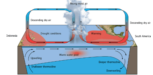
Name this phenomenon.
El Nino
300

At which of the following sites is an earthquake most likely to occur as two plates slide sideways past each other?
A
B
C
D
C
300
Students want to determine the impact of soil erosion from the development of new housing. They plan to measure the density of a species of algae growing along the bottom of a river that flows through their town. The town is built in a heavily forested area, but a large area of trees along the river was recently clear-cut to allow for the construction of a new housing development, which has caused exposed soil to wash into the river. The river flows north to south through the town and is still forested both up- and downstream of the town.
Which of the following explains the variable that would be the best for students to measure to determine the direct impact of soil erosion caused by the construction project on the river?
A. Water temperature, because a decrease in shading in the area would indicate an increase in soil erosion.
B. Nutrient levels, because a decrease in nitrogen and phosphorus would indicate an increase in soil erosion.
C. The pH level, because an increase in pH would indicate an increase in soil erosion.
D. Turbidity, because a decrease in water clarity would indicate an increase in soil erosion.
D. Turbidity, because a decrease in water clarity would indicate an increase in soil erosion.
300
An environmental engineer wants to examine the permeability of different soils to determine the best natural containment system to protect groundwater from pollutants. The engineer tests four different soil samples, places them into a wet column, and pours 50mL of water over each sample. The engineer records the total amount of water that moves through the column as well as the total amount of time for the water to fully percolate through the soil. The data from the study are shown below.
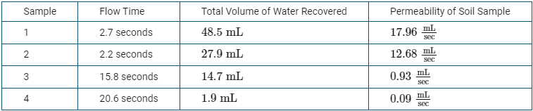
Which of the following best describes the independent variable in this research design?
A. The sample of material chosen as the potential container material is the variable being tested, so it is the independent variable.
B. The flow time, which is related to the porosity of each sample, is the variable that is measured, so it is the independent variable.
C. The total volume of water recovered is most likely to be affected by human error and is the variable with the largest range of values, so it is the independent variable.
D. The permeability of each soil sample, which is determined by dividing the total volume of water recovered by the flow time, is the variable that is calculated, so it is the independent variable.
A. The sample of material chosen as the potential container material is the variable being tested, so it is the independent variable.
300

Based on the diagram, which of the following identifies a characteristic of the atmosphere between the stratopause and the tropopause?
A. Cloud formation occurs in the stratosphere.
B. The warmest air is found in the mesosphere.
C. The ozone layer is in the stratosphere.
D. The troposphere is the closest layer to the sun.
C. The ozone layer is in the stratosphere.
300
Which of the following is a biome found at 30° � and 30° � as seen in the diagram?
A. Rain forests
B. Tundras
C. Coniferous forests
D. Deserts
D. Deserts
300

Name a structure that would be considered part of the catchment.
River/Sea
300

If the diagram illustrates Earth’s relative position on December 21 of a given year, which of the following statements would be correct?
A. The Tropic of Cancer has a shorter day and higher solar radiation intensity because there is an inverse relationship between length of day and radiation intensity.
B. The Tropic of Capricorn has a shorter day and higher solar radiation intensity because there is a direct relationship between length of day and radiation intensity.
C. The equator has twelve hours of daylight and the greatest solar radiation intensity because there is no direct relationship between day length and radiation intensity.
D. The Tropic of Cancer has a shorter day and lower solar radiation intensity because there is a direct relationship between day length and radiation intensity.
D. The Tropic of Cancer has a shorter day and lower solar radiation intensity because there is a direct relationship between day length and radiation intensity.
300

Which of the following best explains why City B regularly receives less precipitation than City A?
A. As air rises up the side of the mountain near City B, the temperature and the relative humidity increase, causing increased precipitation on the other side of the mountain over City A.
B. Air that is forced upward on the side of the mountain near City B leads to the formation of stratospheric clouds.
C. The urban heat island from City B causes a warmer climate that leads to reduced cloud formation.
D. The rain shadow effect causes City B to be drier because the mountain blocks precipitation from reaching the city.
D. The rain shadow effect causes City B to be drier because the mountain blocks precipitation from reaching the city.
300
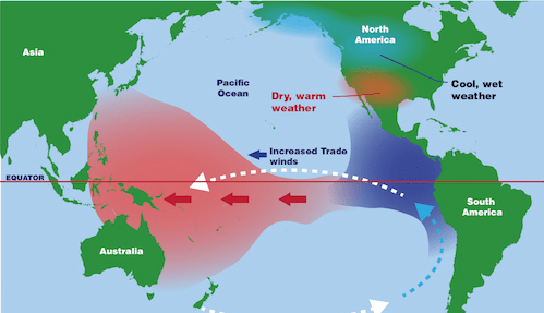
Name this phenomenon.
La Nina
400
At which of the following sites would activity result in volcanoes, island arcs, and mountains?
A
B
C
D
B
400
Students want to determine the impact of soil erosion from the development of new housing. They plan to measure the density of a species of algae growing along the bottom of a river that flows through their town. The town is built in a heavily forested area, but a large area of trees along the river was recently clear-cut to allow for the construction of a new housing development, which has caused exposed soil to wash into the river. The river flows north to south through the town and is still forested both up- and downstream of the town.
Which of the following is the dependent variable in the study?
A. The tract of land that was clear-cut for the housing development
B. A tract of land in a heavily forested area outside of town
C. The density of a species of algae growing along the bottom of the river
D. The flow rate of the river from north to south
C.
400
An environmental engineer wants to examine the permeability of different soils to determine the best natural containment system to protect groundwater from pollutants. The engineer tests four different soil samples, places them into a wet column, and pours 50mL of water over each sample. The engineer records the total amount of water that moves through the column as well as the total amount of time for the water to fully percolate through the soil. The data from the study are shown below.
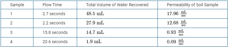
Which of the following best describes why the engineer chose to calculate the permeability of the soil sample in the experimental design in order to evaluate a natural containment system to protect groundwater?
A. Soils that have high permeability would best help protect groundwater because they would allow for faster recharge of the aquifer.
B. Soils that have high permeability would best help protect groundwater because they have higher rates of nutrient and pesticide leaching.
C. Soils that have low permeability would best help protect groundwater because the soil traps pollutants so that chemical and biological breakdown can occur.
D. Soils that have low permeability would best help protect groundwater because the large pore spaces would provide space for pollutants to attach and would have rapid percolation of water.
C. Soils that have low permeability would best help protect groundwater because the soil traps pollutants so that chemical and biological breakdown can occur.
400

Based on the data in the diagrams, in which layer of the atmosphere would short wave radio signals be reflected?
A. Stratosphere
B. Mesosphere
C. Thermosphere
D. Exosphere
C. Thermosphere
400
Which of the following is the source of energy driving the circulation pattern labeled C in the diagram?
A. The Coriolis effect
B. Solar radiation
C. Earth’s magnetic field
D. The spinning core of Earth
B. Solar radiation
400
Hoover Dam is the largest dam in the United States, built on the Colorado River to supply hydroelectric power and flood control. Which of the following best describes a downstream environmental effect of Hoover Dam on the Colorado River watershed?
A. The supply of inexpensive electricity led to population growth and industrial development in cities such as Phoenix and Los Angeles.
B. The Lake Mead Recreation Area, formed by the reservoir behind Hoover Dam, is a popular tourist attraction for fishing, swimming, and boating.
C. The drainage basin of the Colorado River includes 246,000 square miles and serves as a source of drinking water for over 40 million people.
D. The damming of the Colorado River led to a change in stream flow, preventing river water and sediments from reaching the delta area.
D. The damming of the Colorado River led to a change in stream flow, preventing river water and sediments from reaching the delta area.
400
Which of the following correctly describes the season and length of day at the Tropic of Cancer at the time of year shown in the diagram?
A. The Northern Hemisphere is tilted away from the Sun so it is winter at the Tropic of Cancer and daylight is less than twelve hours per day.
B. The Northern Hemisphere is tilted away from the Sun, so it is winter at the Tropic of Cancer and daylight is approximately twelve hours per day.
C. The Southern Hemisphere is tilted toward the Sun, so it is summer at the Tropic of Cancer and daylight is greater than twelve hours per day.
D. The Southern Hemisphere is tilted away from the Sun so it is summer at the Tropic of Cancer and daylight is approximately twelve hours per day.
A. The Northern Hemisphere is tilted away from the Sun so it is winter at the Tropic of Cancer and daylight is less than twelve hours per day.
400

Which of the following best explains why the shaded area receives more snowfall than the other parts of New York, Pennsylvania, and Ohio?
A. Moisture-laden storms from the Gulf of Mexico release precipitation here because of the cool temperatures in the region.
B. Air pollutants from power plants and industrial emissions in the Midwest increase snowfall rates.
C. Moisture picked up from the warmer water in the Great Lakes is deposited as snow downwind.
D. Sea spray from the Atlantic Ocean is carried westward by prevailing winds.
C. Moisture picked up from the warmer water in the Great Lakes is deposited as snow downwind.
400
Which of the following is the most likely effect of a strong El Niño event on the weather patterns in the United States?
a. Wetter weather and cooler temperatures in the Pacific Northwest and warmer temperatures with more snow in the northeastern states
b. Drier weather in the western states and wetter weather in the eastern states
c. Wetter weather and cooler than average temperatures in the southeastern states and warmer temperatures in the Pacific Northwest
d. Overall warmer temperatures and drier conditions throughout the entire United States
c. Wetter weather and cooler than average temperatures in the southeastern states and warmer temperatures in the Pacific Northwest
500
At which of the following sites does seafloor spreading result in rifts and possible volcanoes?
A
B
C
D
A
500
Students want to determine the impact of soil erosion from the development of new housing. They plan to measure the density of a species of algae growing along the bottom of a river that flows through their town. The town is built in a heavily forested area, but a large area of trees along the river was recently clear-cut to allow for the construction of a new housing development, which has caused exposed soil to wash into the river. The river flows north to south through the town and is still forested both up- and downstream of the town.
Which of the following would be the best control sample for the study?
A. A sample of water collected just downstream of the southern forest
B. A sample of water collected just downstream of the housing development
C. A sample of water collected just downstream of the northern forest
D. A sample of distilled water
C.
500
Students sampled several different gardens near their school and measured the percentages of silt, sand, clay, and humus content present in each sample. Their results are shown in the table below.
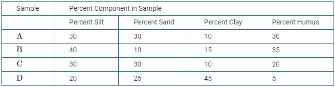
Based on the data in the table above, which of the following samples would be the most prone to becoming waterlogged?
Sample A
Sample B
Sample C
Sample D
Sample D
500

Which of the following correctly characterizes one of Earth’s atmospheric layers?
A. Layer A is the stratosphere, where meteors are found.
B. Layer B is the troposphere, where weather occurs.
C. Layer C is the stratosphere, where the ozone layer is found.
D. Layer D is the thermosphere, where auroras are found.
D. Layer D is the thermosphere, where auroras are found.
500
Which of the following causes the air to rise high into the atmosphere in the areas labeled A, B, and C on the diagram?
A. El Niño circulation patterns
B. The rotation of Earth shifting the direction of the air upward
C. Warm, moist air that is less dense than the surrounding air
D. Rain shadows over mountain ridges
C. Warm, moist air that is less dense than the surrounding air
500
What do these three things have in common?
Keeping houses out of floodplains
Keeping fields covered and reducing plowing
Protecting forests and wetlands
All promote aquifer recharge, reduce erosion and runoff, protect water quality, and reduce flooding.
500
Which of the following areas receives the most intense solar radiation at the time of year shown in the diagram, and why?
A. The Antarctic Circle, because it is closest to the Sun.
B. The Tropic of Capricorn, because this latitude is nearly horizontal to incoming solar radiation.
C. The equator, because it is the hottest region and therefore receives the most intense solar radiation.
D. The Tropic of Cancer, because solar radiation spreads out over a wider area at this latitude.
B. The Tropic of Capricorn, because this latitude is nearly horizontal to incoming solar radiation.
500

In the desert regions of the southwestern United States, daily high and low temperatures will frequently fluctuate by 40°F (33° C) or more. Which statement below best explains the large variation in temperature?
a. There are no bordering oceans or large bodies of water to provide a stabilizing humidity to the air.
b. The nearby Rocky Mountain range provides a rain shadow effect in the evenings to the west.
c. The flat, light-colored sand formations typical in deserts reflect light from the Sun during the day, but not at night.
d. Desert plants have long tap roots that pull water from deep in the soil, cooling the desert at night.
a. There are no bordering oceans or large bodies of water to provide a stabilizing humidity to the air.
500
El Niño and La Niña are natural phenomena associated with changing water temperatures in the Pacific Ocean. The occurrence of these events can result in changes in global weather and ocean circulation patterns.
Which of the following changes in eastern Pacific Ocean food webs is typically associated with La Niña events?
a. Decreased populations of squid
b. Decreased populations of anchovies
c. Increased phytoplankton concentrations
d. Increased famine among sea lions and seals
c. Increased phytoplankton concentrations (Due to stronger upwellings which brings about more nutrients)