Topographic
Plate Boundaries
Weather
Plate Boundaries
Extra, Extra!
100
Elevation
What is the distance above sea level called?
100
Crust Upper Solid Mantle
What layers consist of the Lithosphere?
100
Land
Which warms up faster? (water or land?)
100
Oceanic Crust
What layer of crust underlies the oceanic basin?
100
The distance or difference in elevation between contour lines
What is a contour interval?
200
A line joining points of equal elevation
What is a contour line?
200
Part of ductile mantle
What is the Asthenosphere?
200
Cold water and running into land
What reduces the strength of hurricanes and tropical storms?
200
Convection Currents
What type of currents transfer energy in the mantle?
200
The direction of wind and water is altered by the rotation of the Earth.
What is the Coriolis Effect?
300
Hikers, Military, Geographers
Who would use topographic maps? Hint: Name 3 different groups
300
Continental Crust
What layer of rock forms the continents and also forms shallow sea beds?
300
A band of westerly winds that moves cold air from polar regions in an eastern direction across the US.
What is the Jet Stream and what direction does it move?
300
Matching fossils of plants and animals across continents
What is fossil evidence?
300
On a topographic map, the river will form “V-shaped” curves in the contour lines. The “V” will point upstream.
How would you know which direction it was flowing if there wasn’t an arrow or the ocean in the picture?
400
Topographic maps show the changes in elevation of land from a bird’s-eye view. These maps contain contour lines representing different elevations. Contour line patterns reveal various land features such as hills, stream valleys and basins.
What is the name of the map that shows land features and elevation on a flat piece of paper?
400
German meteorologist Alfred Wegenger
Who discovered the Plate Tectonics Theory?
400
Sea breezes occur during the day
Land breezes occur at night
What is the difference between sea breezes and land breezes?
400
Convergent, Divergent, Subduction, and Transform
What are the 4 different types of plate boundaries?
400
Weathering and erosional agents of gravity, wind, running water, and ice change land features in predictable patterns, making it possible to use topographic maps to predict how the land features represented on the map will change over time.
What is the process of weathering and how does it relate to the erosional process?
500
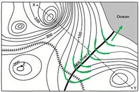
The river is flowing Northeast into the ocean.
What direction is the river flowing?
500
According to the Theory of Plate Tectonics, Earth’s lithosphere is made of plates that move and cause changes to crustal features at plate boundaries.
What is the Theory of Plate Tectonics?
500
Energy from the sun; (Driven by solar radiation, Earth, ocean, and weather systems work together, transferring energy and matter by convection across Earth’s surface.)
What causes convection currents in the oceans?
500
The continents look like they fit together like a puzzle.
Why do we talk about puzzle shapes?
500
Puzzle shape of the continents, Geologic Formations, and similar Glacial deposits
What are three examples of fossil evidence?