Maps
Adaptions and Migration
Culture and Agriculture
100

Using the map above, what country is in North Africa?
A. Somalia
B. Libya
C. Nigeria
D. South Africa
B. Libya
100
The following excerpt describes one of the greatest examples of human migration in history. Read and answer the question below.
Historians and anthropologists are not certain why the Bantu chose to migrate when and where they did. Whatever the reason, the Bantu people began to move and carried their cultural traits and skills along with them. … The many different groups that became part of Bantu culture kept much of their own culture as well. As a result, the nearly 85 million people who trace their history to the Bantu migrations share a very diverse culture today…Today, people whose ancestors were Bantu exist in more than 400 ethnic groups, including the Zulu, the Swahili, and the Kikuyu. Original Bantu languages have evolved into more than 450 languages.
Source: National Geographic: World Cultures and Geography, 2013 (adapted)
Which group helped spread Swahili into the interior of Africa?
Arab traders
Bantu migrants
European traders
Songhai warriors
Bantu migrants
100
What was one of the main problems with the borders that Europeans established in Africa?
A. They crossed too many rivers and lakes.
B. They divided some cultural groups and grouped some rivals together.
C. They blocked British colonies from the ocean.
D. They made it very difficult for French colonists to transport resources.
B. They divided some cultural groups and grouped some rivals together.
200
Q4B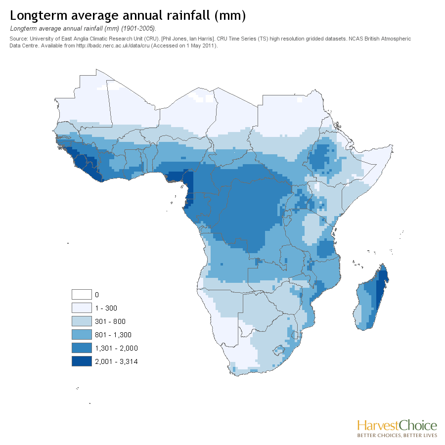
Part B - What conclusion can you draw from this information?
People might move there to fish.
People might move there to grow crops.
People would choose to move north of that area.
People would have a hard time living in that area.
People might move there to grow crops.
200
Q 9A
Directions: Read the passage and answer the question below.
Scramble for Africa
Starting in the 1880s, in what became known as the “Scramble for Africa,” European countries raced to occupy the continent, seeking economic and strategic gains. Britain established control over many parts of Africa, including Sudan and much of the south. France began to rule a large territory in the west and north. Germany, Belgium, Italy, Portugal, and Spain also rushed to gain territory. The map of Africa soon looked like a huge jigsaw puzzle, with the land almost completely divided into separate territories controlled by European powers.
Part A - According to the passage, what was the end result of the “Scramble for Africa”?
A. Africa remained under its own control.
B. Europe briefly colonized, but then left.
C. Europe took control of around half of Africa.
D. Europe controlled nearly all of Africa.
D. Europe controlled nearly all of Africa.
200
 between 1960 and 2005 did maize production increase, decrease, or stay about the same?
A. Increase
B. Decrease
C. Stay the Same
B. Decrease
300
Q1
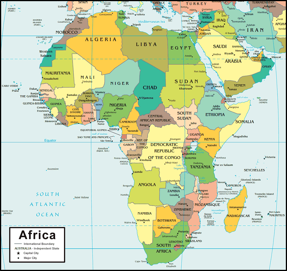
Using the map above, what country is in east Africa?
A. Somalia
B. Libya
C. Nigeria
D. South Africa
A. Somalia
300
Q2
Snow melt and rainfall in the mountains thousands of miles away caused huge seasonal flooding in the Egyptian Nile River Valley. Ancient Egyptians relied on this flooding to bring fresh soil and water into their farm fields. Today there are dams to control water levels and the river valley no longer floods.
According to the passage above, which of the following best describes how the ancient Egyptians adapted to the flooding of the Nile River?
The Ancient Egyptians built dams to control the flooding
The Ancient Egyptians used the flooding to provide fertile soil for crops
The Ancient Egyptians did not have to deal with flooding
The Ancient Egyptians controlled the snow melt in the mountains to protect the crops
The Ancient Egyptians used the flooding to provide fertile soil for crops
300
Q8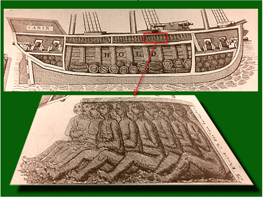
According to the document above, what were the conditions for Africans on board slave ships?
A. Africans were crowded into boats with no personal space
B. Africans could walk easily and explore the boat
C. Africans were chained together, but there was a large amount of space between individuals
D. The trip on the slave ship was long and difficult
A. Africans were crowded into boats with no personal space
400
Q3

Which of the following BEST describes the main idea of this graphic?
A. More grazing land is being planted for cattle.
B. The expansion of desert land is a problem in Africa.
C. Desertification is not a risk in Africa.
D. The Nile River is very important to Africa.
B. The expansion of desert land is a problem in Africa.
400
Q9B
Directions: Read the passage and answer the question below.
Scramble for Africa
Starting in the 1880s, in what became known as the “Scramble for Africa,” European countries raced to occupy the continent, seeking economic and strategic gains. Britain established control over many parts of Africa, including Sudan and much of the south. France began to rule a large territory in the west and north. Germany, Belgium, Italy, Portugal, and Spain also rushed to gain territory. The map of Africa soon looked like a huge jigsaw puzzle, with the land almost completely divided into separate territories controlled by European powers.
Part B - What section of the text gave you this information?
A. “European countries raced to occupy the continent, seeking economic and strategic gains.”
B. “Britain established control over many parts of Africa, including Sudan”
C. “Germany, Belgium, Italy, Portugal, and Spain also rushed to gain territory.”
D. “Almost completely divided into separate territories controlled by European powers.”
D. “Almost completely divided into separate territories controlled by European powers.”
400
Q10

10. According to the chart, which country exports the most diamonds?
A. Central African Republic
B. Angola
C. Nigeria
D. South Africa
D. South Africa
500
Q4A
Part A - Which area of Sub-Saharan Africa gets the most rainfall?
North Africa
East Africa
South Africa
West Africa
West Africa
500
DOUBLE JEPORDY
Directions: Analyze the two images below and then answer the question that follows using your knowledge of geography
Based on the two pictures above, how do humans adapt to their environment in order to survive? How would someone moving from the picture on the left, in the Sahara Desert, to the picture on the right, the Congo Rainforest, change their behavior?
Humans can adapt by by building different homes, wearing different clothes, by figuring out how to grow crops in a hotter climate.
By
Starts wearing less clothing, like shorts and t-shirts
Worries more about insects like mosquitoes or biting bugs
Uses boats to get around instead of a camel
500
Q5
The following excerpt and graph describe the differences between food crops and cash crops:
Agricultural production across Africa has not kept up with population growth. In Zimbabwe, although production of cash crops such as sugarcane continues to increase, the country today produces less maize (corn), millet, and other food crops than it did decades ago.
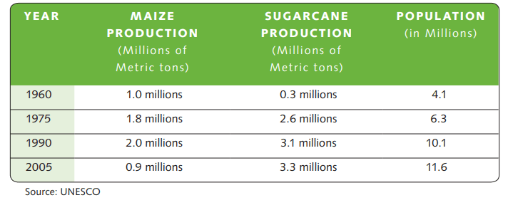
What are the results of farmers growing cash crops rather than food crops?
Select two correct answers.
A. Less food is grown to feed Africans
B. More farmers are growing legumes
C. Many farmers are going out of business
D. Farmland is more susceptible to drought
E. Sugarcane production has dramatically increased.
A. Less food is grown to feed Africans
E. Sugarcane production has dramatically increased.