Hurricanes
El Nino and La Nina
Weather Stations/Mapping
Random
Random
100
74) What is the "fuel" for a hurricane?
74) (C) Warm and moist air
100
70) What weather event is associated with cooler-than-normal water in the Pacific Ocean?
/https://public-media.si-cdn.com/filer/3d/43/3d43e45c-7044-439a-b467-1d20e346e693/photo_-_winter_la_nina_patterns_-_noaa_-_11092016_-_1120x534_-_landscape.png)
70) La Nina
100
45) What is the number one weather-related cause of death in the United States?
45) Flash floods
100
73) A hurricane requires what 2 things?
Hint: _______ water and ________ winds
73) (A) warm water and strong winds
100
49) What is the difference between wind chill and heat index?
49) Wind chill: the temperature you feel when you combine air temperature and wind. Heat index: the temperature you feel when you combine air temperature and humidity.
200
75) The most severe weather occurs where with a hurricane?
75) (C) In the eye wall of the hurricane
200
71) What weather event creates colder-than-normal conditions in Alaska and Northern US?
71) La Nina
200
52) Determine the following weather conditions of the location using the weather station model: (use task cards)
Cloud cover, wind speed and direction, temperature, visibility, dew point, present weather, precipitation (in last 6 hrs), air pressure and pressure trend
52) Cloud Clover: cloudy; Wind Speed: 25 knots; Wind Direction: NW; Temperature: 52F; Visibility: 7 miles; Dew Point: 40F; Present Weather: drizzle; Precipitation: .25 inches; Air Pressure: 1015.2 mb; Pressure Trend: falling, 10 mb
200
69) What weather event is associated with warmer-than-normal water in the Pacific Ocean?

69) El Nino
200
51) How does humidity change as the air temperature becomes closer to the dew point?
51) Humidity increases as the air temperature becomes closer to the dew point.
300
76) What are the weather conditions like in the eye of the hurricane?
76) (D) Calm winds and clear skies
300
72) What weather event creates wetter-than-normal conditions in the Southern US?
72) El Nino
300
53) Determine the following weather conditions of the location using the weather station model: (use task cards)
Cloud cover, wind speed and direction, temperature, visibility, dew point, present weather, precipitation (in last 6 hrs), air pressure and pressure trend
53) Cloud cover: scattered clouds, wind speed calm, n/a; temperature: 72F; visibility 10 miles; dew point 62F; present weather: clear; precipitation: 0 inches; air pressure: 1014.2mb; pressure trend: rising, 10 mb
300
66) How are monsoons both beneficial and detrimental to West Africa, Southern Asia and Australia?
66) Monsoons are beneficial because they bring needed rain to the area. Monsoons are detrimental because heavy rains can cause destruction and flooding.

300
56) What type of air mass(es) is/are associated with stronger weather disturbances? Explain.
56) Tropical air masses - specifically maritime tropical. Moisture in the air makes air unstable. When moist air collides with cooler or drier air, moisture is released as precipitation.
400
78) Compare and contrast a hurricane, typhoon and cyclone.
(Hint: you must include location/where)
78) All 3 storms are the same but have different names depending on where they form.
Hurricanes: Atlantic
Typhoon: Western Pacific
Cyclone: Indian Ocean
400
77) Compare and contrast El Nino and La Nina
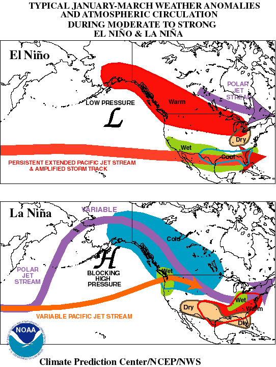
77) El Nino: wet weather in Southern US, warmer in Northern US, cooler in South and SE US
La Nina: wet weather in NW, colder in Alaska & Canada, warm/dry in Southern US
400
62) Draw a weather station model for a location with the following weather conditions:
Few cloud; Precipitation in last 6 hrs: 0 inches; Air pressure: 1020.5, steady; Temperature: 65; Visibility: 10 miles; Dew Point: 50; Present weather: clear; Wind: 30 knots, East
62) Use elmo
400
63) Draw a diagram to show how wind moves around a high pressure system and low pressure system in the Northern hemisphere.


63) 
400
60) What is the difference between a land breeze and a sea breeze?
60) Land Breeze: occurs at night, water is warmer than land, win blows from land to the sea. Sea Breeze: occurs during the day, land is warmer than water, wind blows from sea to land.
500
80) Rank the following storms from weakest to strongest:
Category 2 Hurricane Category 5 Hurricane
Tropical Depression Tropical Disturbance
Tropical Storm
80) Weakest -> Strongest
Disturbance->Depression->Storm->Cat 2->Cat 5
500
79) The southwestern US is prone to droughts. Considering this, is El Nino a positive or negative weather event for locations in the Southwest US? Defend your answer.
79) It is a positive weather event because it brings precipitation to the SW and helps reduce droughts.
500
65) draw an isobar map given the barometric pressure of the following locations. Label High and/or Low pressure systems on the map.

65)

500
68) What type of breeze is produced during the day along the coast of a continent?

68) Sea Breeze
500
61) Draw a weather station model for a location with tthe following weather conditions:
Cloudy; Wind: 25 knots, SW; Visibility: .5 miles; Dew Point: 50F; Present weather: thunderstorms; Precipitation in last 6 hours: .5 inches; Air Pressure: 1013.2mb, falling
61) show on elmo