Types of Maps
Latitude & Longitude
Cartography
Diffusion
5 Themes of Geography
100
A map that uses symbols to communicate to the person reading the map.
Symbolization Map
100
The line you read first when writing latitude & longitude.
Latitude
100
A person who makes maps to communicate something to the reader
Cartographer
100
A wide spreading out across land?
Diffusion
100
the study of earth and its landforms
Physical Geography
200
This is an example of what kind of map?

Simplification Map
200
Another way of saying 0 degrees line of longitude.
Prime Meridian
200
These are examples of what?

Types of scales
200
Spread of ideas from people in power to other people/places in an organized manner "down the ladder"
Hierarchical Diffusion
200
the study of people, their environments, and the resources available to them
Human Geography
300
A map that groups data into ranges and typically color coats each range in shades from light to dark.
Classification Map
300
Arched lines referred to as meridians drawn between to connect at the North and South poles.
Longitude
300
Direction, distance, shape, and size are examples of what?
Types of distortion
300
What type of diffusion is this an example of?

Contagious Diffusion
300
What are all 5 themes of Geography?
Location, Movement, Region, Human-Environment Interaction, Place
400
A map that is designed with a specific focus in mind, usually at the center.
Centering Map
400
Lines drawn parallel to the equator running around the globe from east to west.
Latitude
400
Name 3 kinds of map projections?
Mercator, Robinson, Conic
400
Is the spread of religions an example of relocation diffusion or contagious diffusion?
Relocation Diffusion
400
Planting vegetables in a garden, building roads, and people being shaped by the places in which they live are all examples of what theme of Geography?
Human-Environment Interaction
500
What is this map communicating to you?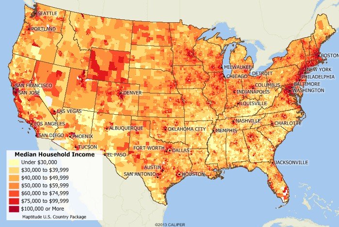
The ranges of median household income across America.
500
What are the latitude and longitude coordinates for point F: Australia?

30 degrees South by 135 degrees East
500
A map display that captures, stores, analyzes and displays geographic data. Data is stored in layers. Also known as a mashup.
Geographic information system (GIS)
500
The example that Mcdonalds serves different items and excludes certain items on their menu in different countries is an example of what type of diffusion? Hint: it changed as it spread to a new culture
Stimulus Diffusion
500
The culture in Hawaii is welcoming and the community greets one another by saying Aloha! They all dress with beach appropriate clothing most often. These are the human characteristics of this area. What theme of geography is this an example of?
Place