1.1
1.2/1.3
1.4
1.5
1.6/1.7
Vocabulary
100
What are the two different types of maps?
Thematic and Reference Maps
100
What does GIS stand for?
Geographic Information System
100
A city’s latitude and longitude describe this type of location.
absolute location
100
true or false: possibilism and environmental determinism are the same thing.
False
100
A region defined by government boundaries, like states or countries, is called this.
Formal
100
The frequency of something within a given unit of area is....
density
200
What type of thematic map is this? 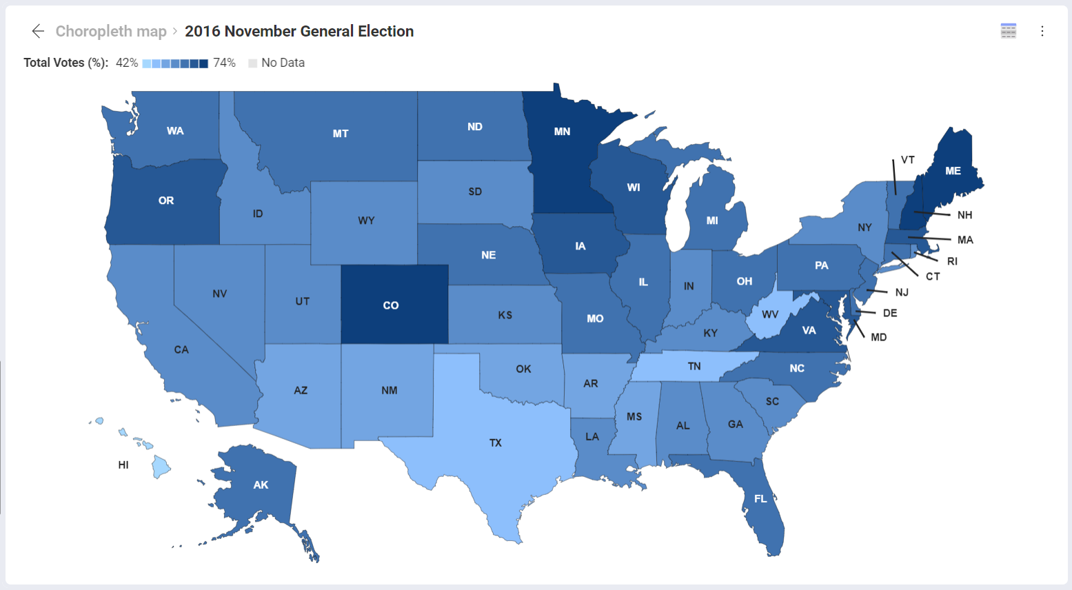
Choropleth
200
This government survey, taken every 10 years in the United States, provides data that geographers use to study population, demographics, and regional patterns.
Census
200
Explain the difference between absolute location and relative location.
Absolute = exact spot-on earth (latitude & longitude)
Relative = your location in relation to other places (north, south, east, west)
200
Give an example of a sustainable practice.
recycling, composting, taking public transportation/walking, etc.
200
The idea of “the South” or “the Midwest” is an example of this type of region.
Vernacular/perceptual
200
A specific point on earth distinguished by a particular characteristic. Is the definition for which term?
Place
300
This type of map projection makes Greenland look much larger than it really is.
Mercator
300
Provide a real-life example of why/how geographers use the GIS system.
map crime, add in schools/businesses, view deforestation. etc.
300
True or False: an example of distance decay is the weakening signal of radio waves as you increase the distance from the radio station
True
300
The theory that climate and landforms strongly shape human culture, and development is known as this.
environmental determinism
300
A region organized around a central point, like the area served by a television station, is called this.
Functional
300
What is a node?
A central point or place that connects to surrounding areas
400
Would a city or county have a larger scale?
city
400
GIS is powerful because it combines different kinds of data in this way.
layering data sets on the same map?
400
Saying that Chicago is located on Lake Michigan and is a transportation hub describes this concept. (site or situation)
Situation
400
The idea that the environment limits some human actions, but people can adjust and adapt, is called this.
Possibilism
400
What is the scale and scale of analysis of this map?
Global scale, national scale of analysis
400
What is time-space compression?
The shrinking of time, or relative distance because of improved methods of transportation
500
Explain the difference between a large-scale and small-scale map.
Large-Scale: example a city map, smaller area, but large amount of detail
Smale-Scale: Example map of the Midwest. larger map, smaller amount of detail
500
Why do geographers use geographic data?
Answers will vary.
500
Give an example of a "site" factor and a "situation" factor
site = physical natural features (soil, rivers, mountains)
Situation = connections features. A place's location in relation to other places. (roads, nearby cities)
500
According to the theory of environmental determinism, which of the following areas would have the most productive settlements?
A. Arid
B. Arctic
C. Temperate
D. Tropical
C
500
Which of the following is an example of scale of analysis?
A. A map comparing rent prices at the state, county, and city level
B. A map showing the physical features of Africa
C. Using latitude and longitude to find Paris, France
D. A thematic map of the climate zones of Earth
A
500
The spread of something over a given study area is ____________________. Hint: There are two kinds; clustered and dispersed.
Concentration